Last time on Nostalgia Album, my father and his parents were heading south in their Ford 8 in the general direction of Madrid. The year is 1952 and Franco’s rural Spain must have appeared un-developed even compared to the austerity Britain they had left behind.
The Spanish capital is announced by a series of one-horse towns along the road from the French border at Irun. One hopes upon leaving the previous episode’s last stop, Aranda de Duero, they had better luck than another notable 1950s adventurer. In August 1959 Birmingham Daily Post reported,
Ernest Hemingway, the novelist, escaped unhurt when the car in which he was travelling burst a tyre yesterday near Aranda de Duero, about 100 miles from Madrid. The Cifra News Agency said the car left the road, tearing its way through some stones placed as protection, but both Mr. Hemingway and another American who was travelling with him were unhurt.
***
The smallest of the photographed settlements on the way to Madrid is Boceguillas in the province of Segovia, Castile and León. By the 2004 census, inhabitants still only numbered 649. A benefit being the opportunity to walk every inch on Street View until you find the buildings in the old pictures.
In a 1896 article in The Field, the country gentleman’s newspaper, a certain Mr C.E. describes his arrival in the township during an epic late Victorian gentleman’s pedal ‘Through Old Castille On A Bicycle’.
Boceguillas is only a village, full of goats, and swine and asses, like other Castillian villages. These came into place in troops at sundown, and it was droll to see how they separated by twos and threes or integers, and made off at a trot for their particular homes.
The menu was meagre; but the salad and the wine made up for other deficiencies. The bed, too, was clean. But I was awoke early by the playful tricks of a porker in the corridor outside and the hilarious crowing of a rooster. Thanks to the pair of them, I was soon off after six o’clock in the early prime of a glorious morning. I hope it may be long ere I forget the picture of the Guardarramas (fifteen miles away) as I saw them then; also the striking effect of the town of Sepulveda at the end of its gorge as I saw it in less than an hour after leaving Bocequillas.
Now bypassed by the E-5 Madrid-Burgos superhighway, the original Carretera Madrid-Irun becomes the Calle Bayona while going through the village. Calle means street, carretera means road. A building to the right at the start of the village might qualify as Mr C.E.’s inn.
Modernised with rendering and a new roof, the mind’s eye, especially with a pillared balcony, lower courses of horizontally cut stone and a courtyard to the front, can easily imagine a 19th-century Castillian hostelry with an English gentleman’s cycle propped beside an open front door.
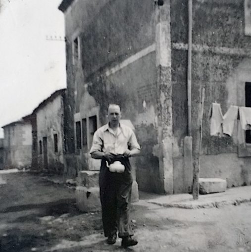
What can be said with complete certainty is if we continue another 200 yards, turn left at the tobacconists and right into the next street, we find ourselves at the precise spot my father and grandparents stopped for water exactly 70 years ago.
Judging by the Nostalgia Album photographs, not much changed in the previous intervening half-century since Mr C.E.’s bone-shaking ride past. The roads are unmade. A cockerel stands in the middle of the thoroughfare, a hand cart rests to one side. Washing hangs to dry in the street. One imagines a touring English gentleman might stop and ask for his kettle to be filled with water.
© Always Worth Saying 2022, Going Postal

© Always Worth Saying 2022, Going Postal
Given the dampness around the place, compared with otherwise parched streets, was the stonework behind my grandfather a public well? I wonder if the indistinct lettering on the wall beside him are the ‘rules of the well’? As a further clue, in the modern-day, manhole covers sit at that point.
The nearest building is easy to find because of the distinctive brick-sized openings above the upstairs windows. The balcony remains too. These days the road is properly made up and is fitted with sewers and drains. These walls have also been rendered and painted an appropriate and fetching deep Castillian clay-earth, close to the red seen on the Rojigualda, the national flag of Spain.
Before we consider the rest of the street, I must remind readers that last time on Nostalgia Album I promised Puffins a jaw-dropping surprise to make even the most difficult to impress reader gasp. Here you are. At the risk of offending the Gods of Street View (I’m not sure how to credit the picture without putting code into the layout and the Gods of WordPress hesitate to allow me to enter my own code), I must share this:

© Google Street View 2022, Google
Beside a scruffy shed in a dusty Spanish village none of us have heard of, the Google car captured the most exquisite, gleaming, marine blue E Type Jaguar Coupe to the right. Eat your heart out Ernest Hemmingway. You can use this Street View link to observe the Jag at close quarters. Puffins who know about such exotic creatures might want to tell us more in an unread comment below this modest unread travelogue. As the only wing mirror sits above the left door, I would venture its a left-hand drive model. Why are there red lights below the front bumper? Although mightily impressed, one wonders if three adults could be comfortably driven between Carlisle and Boceguillas via Biarritz and San Sebastian? Perhaps not.
The building next door hasn’t survived and is replaced by a pub, again built upon a lower course of cut stone this time set in cement. The Bar Eugenio is well regarded by reviewers with, although my Spanish isn’t perfect, the potato omelette being regarded by at least one impressed diner as ‘exquisite’.
Further along the road, the gap between the buildings on the left is now a garden terrace for the pub. The next structure, with the interrupted pitched roof, remains. As does a stick on its end wall protruding above roof level. This leads us to the tower at the end of the street.
Close up, this is revealed to be an electricity sub-station with recycling bins added for good measure. On the original photo, the electric wiring and insulators can be seen on a pole. These days insulated cables are tucked under the overhang or run partway down the outside of the neighbouring buildings.
***
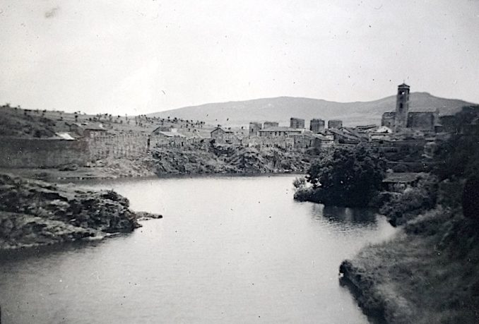
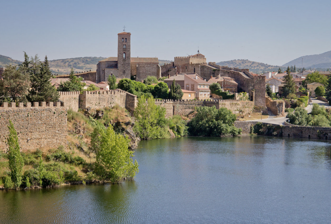
Continuing south, our next photographed port of call is Buitrago (only 34 miles from the outskirts of Madrid), which from some angles presents reassuringly as it did seven decades ago.
© Always Worth Saying 2022, Going Postal
Buitrago del Lozoya, Community of Madrid, Spain.,
Carlos Delgado – Licence CC BY-SA 3.0
The three prominent structures to the left of the church, in the older photo, belong the Castle of Buitrago del Lozoya. As Puffins can already tell, this is a 15th-century castle built in the Gothic-Mudejar style. In total there are seven towers, identical to the three visible in the old photograph. The church tower belongs to the Church of Santa María del Castillo, an early 14th-century structure thought to have been a mosque in times Spain was occupied by North African Moors. Burnt down during the Spanish Civil War of 1936 to 1939, it was subsequently rebuilt by students of the San Francisco de Asís School workshop, where various trades are taught to boys and girls between the ages of thirteen and sixteen.
Lozoya is the name of the pictured river which runs from a reservoir behind a 150-foot high dam at Riosequillo, less than a mile from the township, as a series of nearby dams and reservoirs provide drinking water to Madrid. Because of a post-Civil War boom in the capital’s population, the dam was approved in 1947 and completed in 1958. We shall assume an impressive building site to the right of the Madrid-Irun road as the Ford 8 passed.
In the modern-day, although reassuringly unchanged from some angles, other parts of the town are dominated by the Escuela Internacional GSD complex. According to the guff,
“GSD International School Buitrago proposes a multicultural immersion experience, adding a modern residential campus to the local school where national and international students coexist on a daily basis, being able to take the national study itinerary, from Primary Education to Baccalaureate or Vocational Training and Baccalaureate International.”
Very modern. Perhaps the young people would learn a lot more both about Spain, themselves and life in general if they struck out on a splendid adventure with their own families instead?
By this point, the old Madrid-Irun road ceases to exist and is presumably somewhere underneath the Madrid-Burgos superhighway.
***
In 1910, the Spanish capital had a population of 600,000. By the time my family visited it had risen to 1.6 million and in the present day has doubled to 3.2 million. This means a sprawl of superhighways and turnpikes on the northern approaches to the city making it impossible to trace the precise movements of the intrepid Ford 8. Having entered Madrid via a more interesting route now not possible, we shall assume a stately drive down one of the city’s still existing boulevards.
Given what is to follow, the obvious route would be along the Paseo de la Castellan. This passes Madrid Chamartin railway terminus, a horrible building reminiscent of an outsized Transportation Centre Skopje. Thankfully for them, Chamatin wasn’t built until the early 1970s, twenty years after the family Ford 8 passed by.
Castellan is the scenic route and passes the city’s impressive museums, gardens and Santiago Bernabeu football stadium. In my day, you could have a wander around if you turned up on speck, were keen on football and made the right impression. There was a swimming pool. One could pray in the chapel. Five European Cups sat in a row in a cabinet, another was about the place somewhere. The stands were close to the pitch and consisted of a mixture of seating and terracing on numerous tiers. The players were like gods. In fact God would be obliged to hold the dressing room door open for first team and glance to the marbled floor as they passed. The pitch looked like a billiard table, the second it left the factory. The stadium held 120,000. Halifax away on a Tuesday night in November. Not.
Built in 1947, it would be recognisable today to any who passed in the 1950s. A difference being the completion of the upper tier (to the right) and an accompanying short roof around the whole stadium in the mid-1950s. In the interim, the home of Real Madrid has become all-seated and now this minute is having a retractable roof added.

Madrid, 1955,
Luis Fernández Fuster / E.S. Turismo Huesca – Licence CC BY-SA 2.0
However, the environs have changed substantially, with the above 1955 image showing the ground to be in the suburbs, if not the countryside. The dome to the right is the Parroquia de San Jorge which means the photograph faces north.
Reference to a 1950s map suggests the urban area proper began at the Calle de Raimundo Fernández Villaverde about half a mile south of the Bernabeu. The faded Plano de Madrid also reveals that in those days the avenue we’re following was touchingly known as the Avenida del Generalissimo Franco.
En route the name changes a few more times until it becomes the Paseo Del Prado (as per the neighbouring world-renowned Prado Museum) at the Fuente de Cibeles junction with Calle de Alcala where our intrepid travellers paused to take the next photograph.
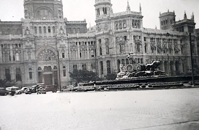
© Always Worth Saying 2022, Going Postal
Have they arrived at their destination? And if not, which turnoff will they use as they circle the statue of Cybele? Will they head west to the gaming tables of Portugal’s Atlantic coast, or south to what Puffin phaasch informed us in an unread comment last time is dirección Granada and the long, dusty roads of southern Spain?
All with be revealed in the next episode of Nostalgia Album!


