I’m glad my account of Sweden and Norway in earlier articles revived memories for several readers who had been there themselves or, like Arthur Dent, had met Scandinavians in Britain. It is quite true in my experience that both are high cost countries for people from UK and especially so for alcohol in all its forms. Arthur’s comment reminded me of another practice sometimes adopted by Scandinavians when a lone Englishman is a guest. Cost is not a concern on such occasions but I’d like to warn readers to beware of repeated toasts in ones honour. It has been known for each Dane, Swede or Norwegian present to propose the toast “Skol ‘Arthur'” in turn. All raise their glasses but amongst the hosts only the proposer takes a sip whilst ‘Arthur’ is expected to drink every time. They seem to think it’s enormous fun to watch ‘Arthur’ getting legless very quickly whilst they all remain sober.
ALCHEMI’S 1997 VOYAGE
Pacific Seacraft’s Agent had asked me to invite a potential customer for a new yacht to come on one leg of this year’s cruise to provide a real opportunity of “trying before buying”. I had agreed and Norman arrived as planned in Bergen, as did Michael whom I had met at sailing school. They had both come earlier in the year for a shakedown sail and refreshed their memories of the controls on the short trip to Hjellestad where we planned to stay for the first night.
The marina manager greeted us with “welcome back” as we tied up and confirmed he had available a replacement Camping Gaz cylinder. But to my surprise he declared the bottle I had thought empty still had a useful quantity of gas inside. So began the next problem that wasn’t resolved until later.
Before continuing I must repeat my normal warning that conditions in Shetland are bound to be different in some respects now from those in 1997.
In addition I’ve had greater difficulty than hitherto in getting half-decent copies of my photos. The hard prints in my journal are fine but I suspect that the scenery and light conditions resulted in contrast being low in many of them. Much higher quality photos are available on the internet for many scenes but I think using my own adds authenticity to my story and I’m writing these articles for my own pleasure as well as yours (I hope). In this one I have digitised my APS prints by taking photos of them with my Nikon D70S instead of using the Canon scanner. They’re still not as good as the original prints but are the best that I can easily produce.
Having reproduced the planning map for the Norwegian Leg so many times I’m relieved to move on to the next one. Here it is –
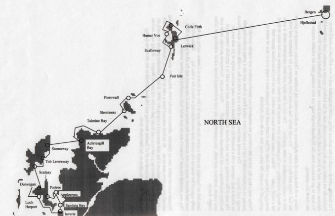
CROSSING THE NORTH SEA
I estimated we would take 40-50 hours to cross the North Sea so we were in no rush to leave first thing on Monday morning when there was a north-west breeze freshening all the time. We left at 13:30 with the marina manager’s warning that the sea would be “too rough for a crossing” ringing in our ears.
For the next 2 1/2 hours we enjoyed one of the best sails experienced in Norway as we raced down the wave-protected inner leads from the marina to the open sea with the wind blowing at about 20 knots.
Heeding the marina manager’s warning we had put two reefs in the mainsail, hoisted the storm jib and fully unfurled the staysail. That sail plan had previously proved to be a very versatile rig that didn’t require anyone to leave the cockpit for winds between 20 and 40 knots .
Alchemi kept going well and comfortably in gently rising and falling waves 5 to 6 feet high when we reached the open sea and those conditions persisted through the night. To maintain reasonable progress in the morning we had to steadily let out more sail as the wind dropped. Later, we replaced the storm jib with the cruising chute as the wind died away even more and veered to the north-east. We reflected that sometimes even local knowledge results in an unreliable weather forecast as we motored gently through the night at 1,500 rpm and 4 1/2 knots over a calm sea (with fuel consumption at just over one litre per hour) .
In these latitudes Venus shows brightly in the sky for quite a long time morning and evening in August and it never got really dark during the short night. We were about 300 miles south of the arctic circle and could always see reflected and refracted light from just over the horizon.
In the morning the wind picked up again from the south east and we merrily sailed along at 6 knots until Shetland appeared on the horizon from many miles away. Rounding Bressay we followed a cruise liner into Lerwick harbour where we were warmly greeted by Shetlanders Bill and Margaret whom we had met in Bergen. It would be hard to imagine more favourable conditions or an easier crossing. They hadn’t been so lucky, with headwinds most of the way requiring three days for the passage we had accomplished in two.
LERWICK AND SUMBURGH HEAD
The rest of the day was spent checking-in with customs, immigration and the harbour master, and the evening in consuming a restaurant-cooked steak and the first English beer I’d had for 3 1/2 months.
We were awakened early on Thursday morning by a boat rafting up alongside and our social circle was completed by the arrival of Jan and May on Fivreld from Skudeneshamn. Long distance cruisers tend to do the same sort of thing at the same time of year and unplanned but repeated meetings are quite common as I discovered in later years on numerous occasions
Tests on the gas problem later showed a new Camping Gaz regulator was needed but neither that nor replacement bottles were anywhere available on Shetland. We had more luck with fresh supplies of APS film, currency exchange, a copy of the Martin Lawrence Cruising guide to North West Scotland and a number of other chores.
On Friday, Norman and I learned a bus-ride and a short hike would enable us to visit Sumburgh Head but Michael didn’t want to go walking and volunteered to pursue a solution to our gas problem whilst we were away.
The bus plies between the town and the airport with vistas of the coast marred by typically drab and utilitarian Scottish municipal housing and private bungalows. The driver helpfully let us down at an unofficial stop from which we could walk for one and a half miles to the headland. It was a sunny day but occasionally a cold mist swirled around the top of the cliffs.
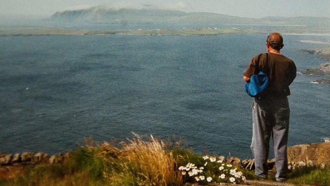
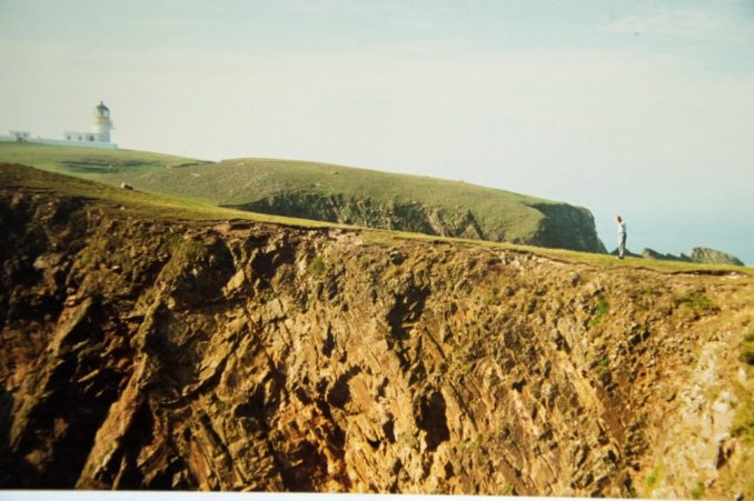
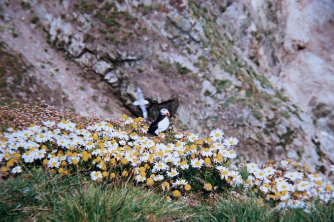
Also swirling round the cliffs above sea level were gulls of many varieties, shags, skuas and puffins. We also saw seals doing the same at sea level. The entire headland is now a protected area and as the lighthouse is no longer manned it provides a wild and beautiful setting for walking, admiring the scenery and viewing the wildlife. Here’s a photo from my journal.
BROCHS AND VIKINGS
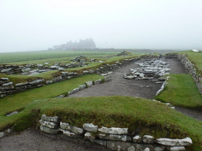
Returning to the road with time to spare before the last bus back to Lerwick we found a local hostelry serving tea near the archaeological site at Jarlshof. This was discovered after severe storms in the late 1800’s swept away some of the sand dunes and low cliffs that had covered it for centuries before.
Dwellings and fortifications spanning a period from the early Iron Age (roughly 1,300 BC) to the 17th Century were exposed to view. They were excavated in the 1920s and revealed buildings and artefacts from primitive cultures, through those using metal, bone and cloth, to the arrival of the Vikings and their gradual mingling with the Scots.
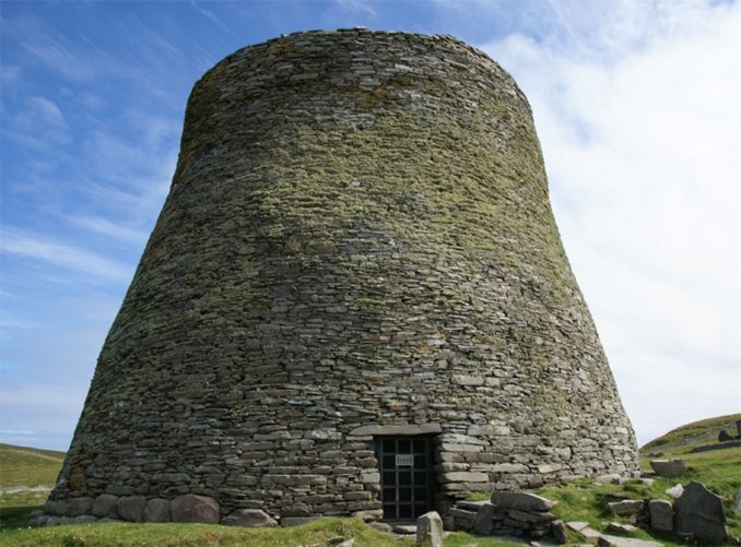
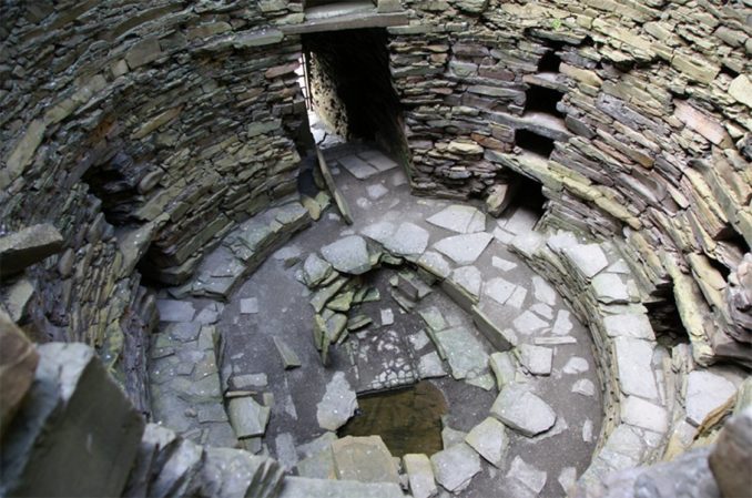
The quantity and quality of the stone buildings is particularly impressive. They demonstrate in the clearest possible way the antiquity of dry-stone-walling techniques including their application to double-walled roundhouses or Brochs. The ones at Jarlshof are substantial but not as well preserved as the one on Mousa Island pictured below.
The viking settlement here has left more familiar remains but only the foundations and lower parts of walls for those have still survived.
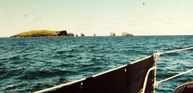
Brochs have been found in many places on Shetland and from a window on the bus taking us back to Lerwick we could see the largest and best preserved one so far discovered which stands thirty feet high on the Island of Mousa.
SAILING ROUND MAINLAND
Michael had achieved success on his mission and proudly showed us the results of his search – a red Calor Gas propane bottle complete with regulator and connecting hose. Our ability to prepare hot drinks and food for the rest of this leg had been secured.
The largest island in Shetland is called Mainland and we decided to circumnavigate it before heading south.
Once we had left harbour the wind blew strongly at 25-30 knots or a little more and we soon sped past Whalsay Island. Pushing our nose into waters between Whalsay and the Outer Skerries we could see higher waves, overfalls and spray rising from rocks awash, right across the sound.
Going round the Skerries seemed a more prudent route but it was soon raining hard with waves some 9-10 feet high and breaking at their crest. We all had oilskins and life-jackets on by now and were clipped at all times to a secure point on the yacht. The motion wasn’t uncomfortable but the downward slope of the waves was steeper than the upward one and I had to work hard to keep the boat going in a straight line as she sped towards a trough before climbing the next wave and doing it all over again,
This was the most demanding sailing I had yet experienced in Alchemi but she kept us safe until we could double back into calmer water in the lee of the outer skerries.
After sailing past the oil terminal at Sullom Voe the wind perversely died away altogether and we had to motor to an anchorage at the southern end of Colla Firth.
We were rewarded in the morning with calm water in beautiful surroundings before sailing pleasantly up the northern end of Yell sound and rounding the small island of Gruney and its adjacent stacks.
ALCHEMI’S MOST NORTHERLY POSITION EVER AT 60:41 N; 1:19 W.
Once round this island we were west of Mainland and in the Atlantic Ocean. The difference was obvious from the wavelength and height of the rollers that came gliding towards us. The shape of the waves was quite different from the short and steep ones experienced the day before and on these Alchemi rose effortlessly to the crests and swooped down the other side whilst maintaining a straight course the whole time thus providing a foretaste of what ocean sailing would be like.
After 10 miles or so we crossed St Magnus Bay and found anchorage at Hamar Voe. There are very few signs of human habitation on the western shores of Mainland and we again had near perfect weather in beautiful surroundings in the morning.
With a 12-15 knot offshore breeze over our port quarter we felt brave enough to sail through Papa Sound under jib alone and with the help of the Clyde Cruising Club’s Sailing Directions negotiated without mishap the two turns necessary to avoid sunken rocks.
Emboldened by that success we confidently entered a bay to the south of Papa Stour to enjoy its well-protected anchorage despite warnings in the Pilot Book of a twenty metre wide passage and a 2 metre depth. Alchemi’s draft was 1.7 metres so provided we were in the centre of the gap there would be 12 inches of water under the keel – and the gap wasn’t wide enough to be off centre to any significant extent!
We made the entrance successfully and once inside the pool things became a little easier but we had to make two or three attempts at setting the anchor before it held to our satisfaction.
The tension drained out of us as we enjoyed lunch in this most isolated of settings and talked of Vikings and early settlers. Then we paid the price for our hubris as we belatedly consulted the tide-tables. We realised we’d have to leave immediately or stay for 24 hours to have enough depth of water to get out again in daylight. None of us fancied trying it in the dark so we hauled up the anchor and set off straight away. It was easier getting out than it had been coming in.
Once again we saw those amazing cliffs across an empty sea with not even a fishing boat in sight. These Shetland waters certainly present a wilder and less domesticated form of sailing than those in Scandinavia.
The wind was blowing strongly as we motored up the short stretch of water towards Scalloway harbour wondering where we’d be able to stay the night.
We didn’t have to worry because we had no sooner come into view than two brawny Shetlanders were waving us in to a pontoon at which they helped us moor. One was the Commodore of the Scalloway Boating Club who invited us to use all their facilities. We enjoyed their bar and a band that was already in full swing celebrating the conclusion of their three-day Annual Regatta.
To be continued …………….
© Ancient Mariner 2021