
Despite finding San Salvador to be a much more pleasant place than expected, we shall strike into the provinces and catch our breath in a guest room in the sticks. En route, we shall allow ourselves to be distracted by a dormant volcano or two as we head northwest along the Pan-American highway whose 19,000 miles pass through El Salvador en route from Southern Argentina’s Ushuaia to Prudhoe Bay in Alaska.
The Big Mouth
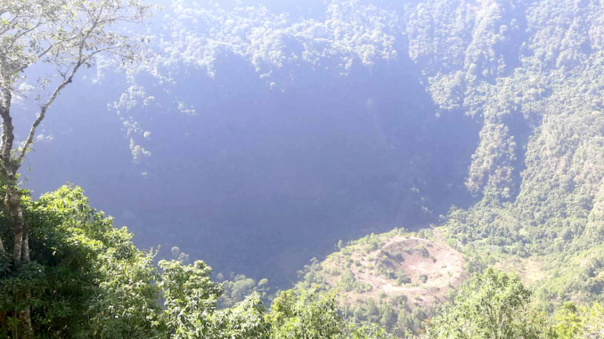
The Boquerón volcano whose foothills reach the outer western subdivisions of San Salvador is part of the San Salvador National Park which encompasses the crater and the surrounding area. The volcano is a ‘stratovolcano’, characterized by its steep slopes and conical shape which reach an elevation of 6,211 feet above sea level. The volcano’s main feature is its massive crater which is approximately a mile wide and 1,830 ft deep.
The Boquerón is part of the Ring of Fire, a region known for its high volcanic activity and frequent earthquakes that spans both sides of the Pacific Ocean. It is the youngest of the volcanoes that form the San Salvador Volcanic Complex, which includes several other volcanic formations in the area.
© Always Worth Saying 2024, Going Postal
The last major eruption of the Boquerón occurred in 1917, presumably creating the smaller cone within the cone known as the Boqueroncito. Since then, it has been relatively dormant, with only minor fumarolic activity observed within the crater.
With the higher land providing a cooler, temperate climate all year round, the surrounding area is rich in biodiversity, with varied flora and fauna inhabiting the national park. The lush forests and diverse ecosystems provide a habitat for ornamental plant species such as cartuchos, hydrangeas, begonias and wild sultanas. There is wildlife such as armadillos, raccoons, deer and foxes. The national park offers various recreational activities, including hiking trails that lead visitors through the scenic landscapes and up to the crater rim. Picnic areas and viewpoints are also available.
Travellers are urged to be cautious when ordering a taxi or inspecting a bus route. Boquerón translates as ‘big mouth’ with many volcanos in the area being similarly nicknamed.
Striking further north-west on the Pan-American highway we take a slight detour to another volcano, this time the flooded Coatepeque
Coatepeque
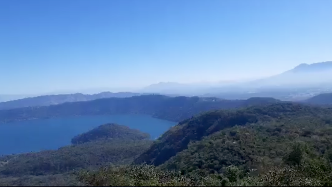
Lake Coatepeque is a large crater lake located in the eastern part of the Coatepeque Caldera. It covers an area of approximately nine and a half square miles and has a maximum depth of around 400 feet. The lake is known for its stunning beauty, with crystal-clear blue waters and picturesque surroundings, including steep green slopes rising to 1,640 ft high.
© Always Worth Saying 2024, Going Postal
Visitors to Lake Coatepeque have the chance to experience various activities, such as swimming, boating and kayaking. Additionally, the lake’s serene ambience and panoramic views make it an ideal spot for relaxation and the enjoyment of natural beauty. There are several open-air restaurants and grills along the lake’s edge, providing opportunities for visitors to savour local cuisine while taking in the spectacular sights.
The lake and its surroundings are home to a diverse range of flora and fauna. The area is also known for its hot springs near the lake margins.
Lake Coatepeque holds cultural significance and is considered a mystical and sacred place by indigenous communities. Its beauty has inspired artists, writers, and poets, making it a source of cultural inspiration in El Salvador.
The Coatepeque Caldera was formed during a series of rhyolitic explosive eruptions between about 72,000 and 57,000 years ago. Over time, basaltic cinder cones and lava flows formed near the west edge of the caldera, and six rhyodacitic lava domes have since formed. The lake’s island of Teopan holds historical importance as a Mayan site.
Santa Ana
As we re-join the Pan American highway we are about to reach our destination of Santa Ana, a city of over 300,000 situated 40 miles northwest of San Salvador and at an elevation of over 2,000 ft. According to the guff, a vibrant city renowned for its rich history, cultural heritage, and architectural landmarks. As the second largest city in the country, it serves as a significant hub of commerce, culture and tourism, attracting visitors with its colonial charm and lively atmosphere. In reality, it’s a bit rougher than that and sprawls. But its centre retains gap-toothed gems of a prosperous and self-confident small provincial city from the Spanish Colonial era.
Before the arrival of the Spanish conquistadors, the area around present-day Santa Ana was inhabited by indigenous Pipil and Lenca peoples. These indigenous communities had established settlements and cultivated the land, leaving behind a legacy of cultural traditions and agricultural practices.
The city was officially founded on July 26, 1569, by the Spanish conquistador Diego de Alvarado. It was established as a colonial town, and its development was influenced by Spanish architectural and urban planning concepts. The Spanish colonial period brought significant changes to the region, including the introduction of new customs, language, and religious practices.
During the 19th century, El Salvador, including Santa Ana, was part of the Federal Republic of Central America, which gained independence from Spain in 1821. The city played a role in the political and social developments of the newly independent nation, experiencing periods of growth and transformation.
Santa Ana’s history is intertwined with the economic and cultural development of El Salvador. The city became a centre of commerce, agriculture and industry, contributing to the nation’s economic prosperity. Its cultural institutions, such as theatres, churches, and public spaces, reflected the city’s growing importance and its residents’ artistic, intellectual and entrepreneurial endeavours.
It also brought the railways!
The Salvador Railway Company Limited
The first line in El Salvador ran from Sansonate to the port of Acajutla on the Pacific Ocean. It opened in June 1882. Built by a British private company, The Salvador Railway Construction Co., several other routes followed over the successive couple of decades. These were operated by another British-controlled company, The Salvador Railway Company Limited and were generally of the 3ft narrow gauge. By April 1900 a telegram had arrived in a London office announcing a line to the capital San Salvador was now officially inaugurated.
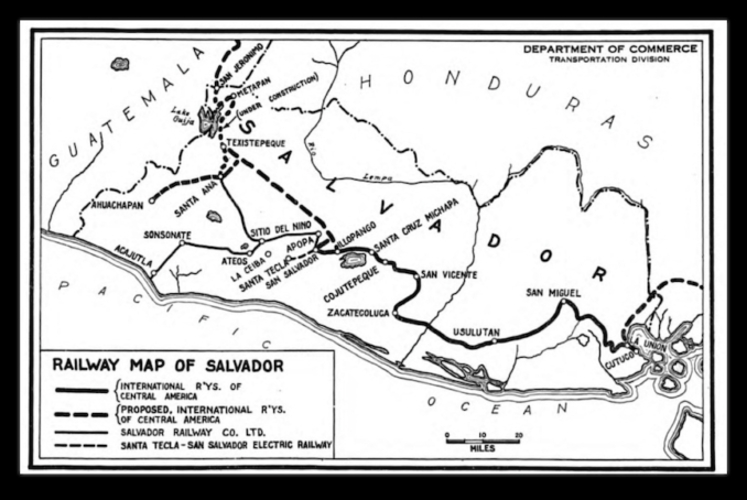
El Salvador rail map of 1925,
W. Rodney Long – Public domain
In November 1902, the Salvador Railway Company Limited’s annual meeting troubled the pages of Herapth’s Railway Journal. Chairman Mr Guthrie reported he had visited Salvador since the last annual meeting and found the railways to be in ‘excellent condition’ with prompt and efficient workings. Gross receipts of 556,714 silver dollars were slightly above the previous year despite a 30% shortage in the coffee crop – the staple export. The rains were now satisfactory, planters were expecting a good crop and the company had plans for a central custom house at San Salvador from which coffee concentrated from throughout the country could be dispatched by rail to Acajutla.
In November of the same year, the directors had to ‘return to the well’ with Herapth’s reporting an extraordinary meeting called to create and issue new stock to ensure the embarking and disembarking of goods could be profitably placed under the company’s control. A managing director was to be embarked to Salvador to carry out these arrangements. Moved and seconded, the resolution was carried unanimously by the assembled deep-pocketed shareholders.
By 1911, the company was also operating steamships. Less dependent on coffee, the railway carried increasing volumes of both sugar and passengers. However, another trip to well beckoned with £110,000 of bearer bonds being offered to lucky stockholders. The investment would pay for two new ships and the employment of a ‘thoroughly competent man’ at a new special agency at Salina Cruz, the Pacific terminal of Mexico’s Tehuantepce Railway. Ominously chairman Mr J Kelly ended his presentation by noting the near future might witness a complete transformation of economic conditions in the Spanish American Republic to the detriment of European capital.
Sure enough, the Spanish American Republic didn’t survive and neither did the railways.
From the Railway Line to Parque Libertad
These days, no trains run in El Salvador and judging by the view from an air-conditioned bus on the Pan-American highway it is difficult to believe that such a network ever existed. But there are hints in the back streets of Santa Ana – with the help of a map. We’re looking for the long, straight lines and sudden uniform curves beloved by engineers from Crewe or Carlisle and necessary for a Puffing Billy with sealed box cars making its way between volcanic mountains for the coast. We find them about a mile due west of the old colonial city centre’s Cathedral of Santa Ana. Remember, the railway was built to move coffee from the countryside to the port, not to move people from city centre to city centre.
Although Puffins might find it difficult to believe, as the trackbed is buried by a road onto which the improvised dwellings of the locals encroach, trust me, you’re looking down the old railway line.
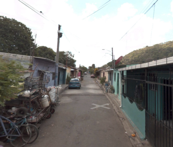
© Google Street View 2024, Google.com
Puffins can have a look around here.
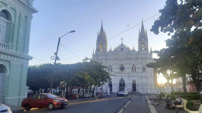
Strolling from the covered trackbed toward the cathedral takes us back to the better world of Spanish colonialism. After passing the seminary and Calvary Church, with its attendant Isidro Menendez Park, we stand outside the National Theatre and have an opportunity to appreciate the intricate design and imposing façade of the Cathedral of Our Lady of Santa Ana.
© Always Worth Saying 2024, Going Postal
One of an encouraging number of well-preserved nearby buildings, this grand structure dominates the city’s skyline. Constructed in the late 19th century, the cathedral’s intricate design makes it a must-see for visitors interested in historical and religious architecture. Additionally, the Teatro Nacional de Santa Ana, an elegant theatre dating back to the early 20th century, stands to our left as another architectural gem and a venue for cultural events.
You can have a look around here.
The original cathedral was built between 1575 and 1576 but was destroyed by lightning in the 19th century. Begun in 1906 it is of the neo-Gothic rather than Spanish colonial style. Seventy-foot high naves intersect to form a cross beneath which sit 28 paintings and statues, four confessionals, 118 pews and 51 lamps. Above, two bell towers hold six bells, three of which were imported from the Netherlands in 1949.
All these buildings clustered around the Parque Libertad were sponsored from the proceeds of the “Golden Age of Coffee”. Patrons were Santa Ana businessmen who owned important coffee processing plants. La Hacienda El Molino, owned by the Colombian Rafael Alvarez, was the main plantation whose coffee processing plant became famous because of its technological modernism for the times.
© Always Worth Saying 2024, Going Postal
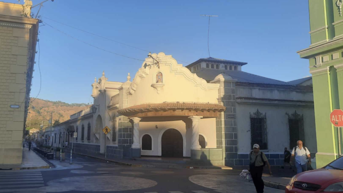
Every cathedral needs a casino next door. The Santaneco Casino pictured above was the idea of Santiago Díaz. The original building was constructed in 1896, with a Mr Emilio Belismelis being the first president of the board of directors. Half a century later, the casino facilities were remodelled in the Baroque style by Armando Sol. These days, The Santaneco Casino is a community space used for parties, congresses, seminars and social events.
The white building pictured to the left is the municipal palace (or town hall) which really is a palace. To the right, the building lit green by the setting Central American sun is the theatre.
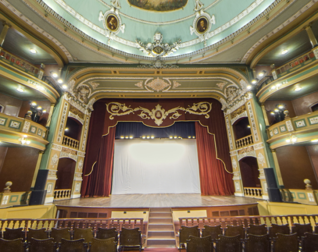
Santa Ana National Theater rubs shoulders with the Santa Ana Cathedral around the Parque Libertad, which became the city’s centre after the Spanish takeover in the 17th century. After a decade of construction, the theatre finally opened in 1912 with a curtains up for the Italian opera Rigoletto.
With no expense spared, elements are borrowed from the world’s greatest theatres. Three levels are linked by sweeping staircases. Salons are lit by crystal chandeliers dangling from painted ceilings.
Beneath a domed roof, local coffee growers in competition with their contemporaries in San Salvador funded stained glass, sculptures, wooden staircases, those glorious chandeliers and more. The entrepreneurial spirit survives. Wandering in from the street to admire their handiwork will cost you a ‘foreigner’s rate’ of $5 plus another $2 to take a photo.
© Google Street View 2024, Google.com
Footnote
The Tehuantepce Railway is still there, is operated by the Mexican Navy and recently took delivery of a batch of redundant British HSTs.
© Always Worth Saying 2024


