Cape Wrath

© Google Maps 2023, Google licence
Cape Wrath is a cape located in the Durness parish of the county of Sutherland in the Scottish Highlands. It is known for being the most north-westerly point in mainland Britain and boasts beautiful sea cliffs and sea stacks. The area is owned by the Ministry of Defence and is mostly used for military training and sheep grazing. Cape Wrath is also part of the North West Highlands Geopark and has been declared a Site of Special Scientific Interest, Special Protection Area, Special Area of Conservation, and Special Landscape Area due to its unique and isolated landscape. The Stephenson lighthouse, which is now automated, is a Category A listed building and stands at a height of 400 feet above sea level. Access to Cape Wrath is only by passenger ferry and then an 11-mile walk along a military track to reach the lighthouse.
Durness
Durness is a remote village and civil parish located in the northwest Highlands of Scotland. It lies 10 miles in a straight line to the southeast of Cape Wrath, although the visitor should be made aware that there isn’t a pubic road between the two and that navigating around the Kyle of Durness lengthens the journey. The name Durness is believed to have originated from Norse or existed as an existing Gaelic name. The area has prehistoric remains and artefacts dating back to the Neolithic, Norse, and Iron Age periods, with four caves near Durness housing ancient artefacts. Durness was part of the bishopric of Caithness, and the old house at Balnakeil was originally the bishop’s summer residence. The area was inhabited by the Clan Mackay and was important to the Clan Morrison. The village has a rocky coastline and pristine beaches with turquoise waters, making it an ideal tourist destination.
The Highland Clearances caused a significant decline in population here. In the 1840s the Durness Riots occurred when women defied the Sheriff Officer sent to deliver eviction summons. Previously in their late 1950s Ford Prefect road trip, my grandparents visited the sites of Bonnie Prince Charlie’s arrival and departure from Scotland. The latter, after the defeat of the Jacobites at Culloden Moor in 1746, resulted in clearances of the inhabitants from their Highland farms. But what is less well known is that the process continued for over a century, driven by agricultural, economic and political change.
© Always Worth Saying 2023, Going Postal
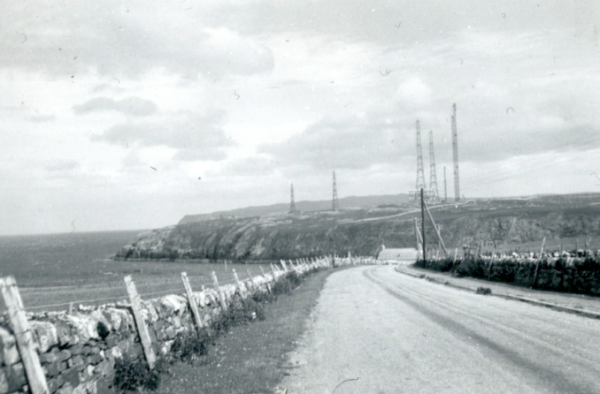
Durness Wireless Station, also known as RAF Sango, was a top-secret radar station used during World War II for training activities and coastal radar defences. It played an important role in providing early warnings of nuclear attacks and was vital to the RAF Mastery in the Battle of Britain. The national service called many local men to work at the station, and the work done there was unknown to the locals. The station had its own transport, including a garage that is still in use today. Many buildings from the 1940s and 50s, including Durness Wireless Station, were dismantled within ten years of the war’s end. Today, the area has a Freeview HD transmitter. Durness Wireless Station is also known as Sangomore, Smoo Radar Station, and Gee Station, and was a Type 7000 Radar Station.

© Google Street View 2023, Google.com
In the modern day, we can stand at about the same spot. The headland looks the same but is shorn of wireless masts. There are more buildings about. Closer inspection shows them to be a campsite, general store and caravan park. What can’t be made out clearly in either photograph is Durness’s magnificent beach.
John O’Groats
John O’ Groats is a small village located in the far north of Scotland, approximately 2.5 miles northeast of Canisbay, Caithness. It is famous for being one end of the longest distance between two inhabited points on the British mainland, with Land’s End lying 876 miles southwest. However, it is not the northernmost point of mainland Great Britain, which is the nearby Dunnet Head. John O’ Groats is named after Jan de Groot, a Dutch man who operated a ferry to Orkney from the Scottish mainland and charged four pence a trip, which was called a groat. The village has a population of about 300 and is popular with tourists from across the globe. Tourists come to John o’ Groats to take photos next to the famous “Journey’s End” signpost which displays the distance to different destinations. The village also offers stunning views of the Orkney Islands and a coastal path that stretches three kilometres to the Stacks of Duncansby. Visitors can also explore The Castle of Mey, which is located six miles away and was the residence of the late Queen Elizabeth.
© Always Worth Saying 2023, Going Postal
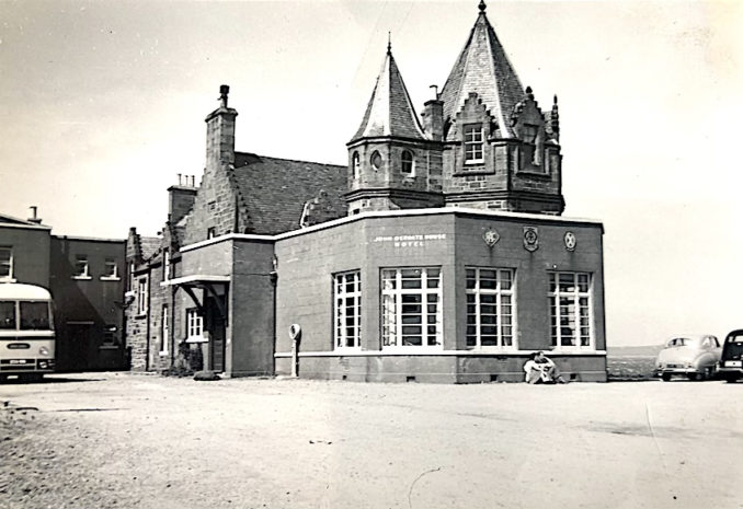
The John o’Groats Hotel is a historic hotel located in the village of John o’Groats in Caithness, Scotland. The hotel was first built in 1875 as a coaching inn, serving travellers who were making the long journey from Inverness to Thurso. Over the years, the hotel has been renovated and expanded, and it now features 23 guest rooms, a restaurant, and a bar. The hotel is situated in a stunning location, overlooking the Pentland Firth and the Orkney Islands. It has been a popular destination for tourists visiting the Scottish Highlands for over a century.
© Google Street View 2023, Google.com
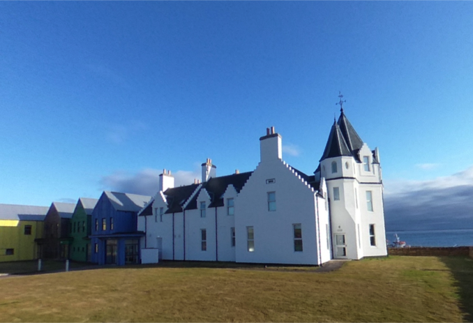
The hotel can be viewed from the same angle today. Rightly, the slab-sided extensions have been removed and, rightly or wrongly, the original granite structure is covered in white rendering. The car park has been turfed and a new extension built, this time as a series of not unattractive barns of coloured timber with pitched roofs.
© Always Worth Saying 2023