
RESPONSES
Joe Slater is obviously more familiar than I with written Chinese Characters and I thank him for explaining that Zheng He and Cheng Ho were one and the same person. When visiting the museum in Malacca I couldn’t figure that out for myself and supposed Zheng was leader of the expeditions and Cheng his sailing master. Joe’s comment makes things a lot simpler and clearer.
I also accept Zheng’s voyages were slightly earlier than the Portuguese exploration of the Atlantic, though not by much. Zheng’s seven voyages were made between 1405 and 1430. The Portuguese and Spanish had already discovered the Canary Islands by 1415, the Azores Islands by 1427 and in 1434 the commander of one of Henry’s expeditions was the first to go south of Cape Bojador on the west coast of Africa. These Portuguese voyages were motivated partly by curiosity about the world but those around the African coast were also aimed at finding a way to break the Berber monopoly of trade in African gold by establishing a route to its source south of the Sahara.
I find it implausible that news travelled so quickly over the long and difficult land routes between East and West for either the Chinese or the Portuguese to have learned about the other’s exploits. My own interpretation of events is that the Chinese and European civilisations independently developed quite different ship designs and sailing techniques suitable for long sea journeys in their respective oceans.
Its also clear the Chinese vessels were much larger and that’s consistent with Chinese motivation being partly to impress less “developed” states with Chinese technology, wealth and power – just as they are doing these days with their Space Programme, Nuclear Research, and other advanced technologies.
Where I think Joe and I are agreed is in accepting the Spanish and Portuguese continued with their expeditions until they had circumnavigated the Globe whereas the Chinese abandoned them because they thought the cost was too high, especially at a time when they were at war with Mongols on their north western border.
The Han Chinese reached the peak of their power during the Ming period and some might argue that happened, at least in part, because they deployed in other ways the resources previously spent on Zheng’s expeditions. There are endless speculative possibilities but what actually happened was that the Han Chinese were succeeded by the Manchus who established a unified state with much enlarged boundaries very similar to those recognised today. This was governed by a multi-ethnic ruling class led by the Qing dynasty of the Manchus. It was so successful that by the end of the 18th Century China became the most prestigious power in East Asia, with surrounding states acknowledging their supremacy and paying tribute.
I recommend Puffins read “The Collision of two Civilisations” by Alain Peyrefitte to understand how Europe and China had evolved so differently from one another by the end of the 18th century that each failed completely to understand the other. It is an account of Lord McCartney’s Diplomatic Mission to China in 1793 that I thought was essential reading when my job required me to visit mainland China many times in the early 1990s.
It was the failure to reach agreement during this Mission that led to the Opium Wars. The proximate cause of those was a world-wide shortage of silver because the Chinese insisted on payment in that metal for the goods they sold to western countries but wouldn’t part with it for goods proffered by westerners. The British were consequently short of silver but had plenty of opium made from poppies grown in British India.
Some Chinese merchants accepted that as payment because they found a high demand for it amongst their local population. The Qing government strongly disapproved of that and war twice broke out with each being won by the British. One result was the establishment of Hong Kong as a British Colony and trading base, extended after the second war by the addition of the Kowloon peninsula and extended again in 1898 by an agreed 99 year lease on the New Territories.
History has been rhyming again in living memory, this time with the Chinese as the dominant side. The handover of Hong Kong, Kowloon and the New Territories happened in 1997, the year of the Voyage these articles are based upon, China’s purchases of Gold during the last few years are eerily reminiscent of their Silver policy in the late 1700’s, the “Belt and Road” policy Joe mentioned looks remarkably like a plan to establish a modern version of China at the center of Civilisation and Trade across the world mirroring Qing ascendacy in Eastern Asia before the opium wars.
Given the unstable indebtedness of the West are we headed for a time when China will establish a new world currency based on gold and only accepting payment in that metal? What will be the reaction of the United States in that eventuality? I doubt I shall live long enough to find out but think it quite likely some Puffins will – unless the wheel of fate takes another unforseen spin and ends up pointing in some completely different direction.
I was sufficiently intrigued by SharpieType 301’s remarks about the size and shapes of a carrack to look into their design in a bit more detail. Here is a summary of what I learned from this website and others.
The high Aft and Fore Castles were adopted to give a vessel’s crew an advantage over others in both defence and attack. The term “Fo’csle” to describe crew’s quarters, was all that survived after a few hundred years though it is noteworthy that some modern ships again have high accommodation towers at the front or stern – Oil Rig service ships often having the former and Container Ships and Tankers the latter.
Carracks, which preceded Galleons, were large ships with sufficient volume and stability to carry a great deal of cargo and a large crew when sailing in bad weather. The Flor de la Mar had a 400 ton displacement and the Mary Rose, a century later, started with 500 tons but was converted to 700 in 1536.
Shipwrights of the era recognised the need to ensure stability against rolling and tried to allow for that by avoiding too much weight too high in the vessel. When doing that they had to rely on precedent and experience because the mathematical techniques for doing so by calculation hadn’t yet been developed. Generally, they succeeded, but mistakes were made.
They are particularly highlighted in the cases of the warships Mary Rose, and the Swedish Ship Vasa. The inherent problem for both was too much weight too high above the waterline compounded by open gunports resulting in water pouring in during heeling whilst tacking.
The Vasa case was a perfect example of Sharpie’s concerns because she, the most powerful warship of the era, sank on her maiden voyage despite having 120 tons of stone ballast low down in her hull! The ensuing enquiry was an excellent example of how the phases of a major project failure develop – Enthusiasm – Disillusion – Panic – Search for the Guilty – Punishment of the Innocent – Promotion for the Uninvolved.
As I write, I wonder if those are the phases we are currently witnessing with the Boris Johnson Administration.
The Flor de la Mar successfully made several trans-oceanic voyages but was lost somewhere in the Malacca Straits off the coast of Sumatra. As far as I can discover the wreck has not been found and the exact cause of her sinking is not known. The straits are shallow, there are many sandbanks and the currents are strong in places, so it’s possible she just ran aground and couldn’t get off again.
DJM mistook my remarks about his comment on the location of his RIB to be a rebuke. It wasn’t intended that way and I only introduced Bertrand Russell’s insistence on agreeing definitions at the start of a discussion to illustrate I was just as much to blame as he for failing to agree clearly which harbour we were talking about when the matter first arose. He also set me a challenge to identify a stretch of water in a photo he included with his comment that had been the subject of a bet with his brother-in-law resulting in his most harrowing sail yet.
I have to confess that I cannot do so from certain knowledge. All I have to go on is a rather dark photo of a narrow and twisting channel in a high gorge with a main road near the water’s edge above muddy banks in what is obviously an estuarial area with a high tidal range.
I hazard a guess it might be the River Avon somewhere near the Clifton Suspension Bridge with Bristol upstream and the road being the one my Mother used to cycle along when commuting to work in Avonmouth circa 100 years ago. I think the road may have been called The Portway.
There, I may have made a fool of myself, but no more than DJM did in taking on such a bet in such a location where wind strength and direction was bound to be highly variable and currents strong. I look forward to learning the actual location and am relieved DJM obviously survived the experience wherever it was – I’m left wondering if he won his bet.
THE 1997 VOYAGE
We last left Alchemi on a buoy near Goat Island in Loch Craignish at which I had stayed an extra day to finish reading Stevenson’s stories about the life of young David Balfour.
Here again is the planning map to help you locate the place and the next sections of the voyage.
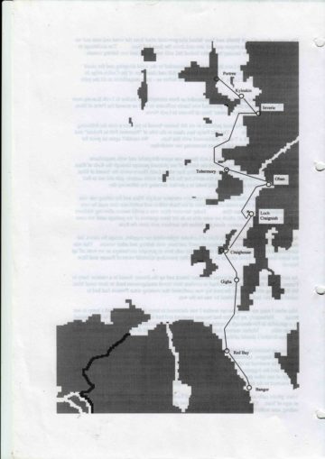
You will see the overall requirement was to make distance to the south with some sections having a slightly western inclination and others slightly eastern. It was now the middle of September just a few days short of the equinox when Gales and Spring Tides are strong. Furthermore, the pattern of low pressure systems crossing the Atlantic at frequent intervals generates winds in these latitudes that typically blow from the south west, through south, to south east as the low passes from west to east. I was not expecting an easy passage and that was just as well because I didn’t get one.
FROM ONE GOAT ISLAND TO ANOTHER
By 09:00 on Friday 12 September I had cleared the rocks across the entrance to Lock Craignish and was motor-sailing SSW in rain through the northern part of the Sound of Jura into the teeth of a strong WSW wind.
The rain soon cleared and was followed by one squall after another as I switched off the engine and continued with one reef in the main, the staysail and a partially furled jib. At times Alchemi was a little hard-pressed and the lee rail dipped under but there were few large waves as the fetch from Jura was quite short.
The sun always came out again as each squall passed and I could watch it race up the Sound to buffet and drench people farther north. Sometimes, on the fringes, there would be a rainbow of breathtakingly perfect shape and composition.
The squalls became more frequent as I approached the Pap of Jura and becoming tired of heeling all the time took in the jib entirely. Alchemi was perfectly happy with this arrangement and sailed on at about 5 knots in a more upright position in winds of around 25 knots.
Approaching Craighouse Bay I managed to sail through the gap between an underwater reef and Goat Island (yes, another one, – the Scots of yore must have prevented livestock from roaming by marooning them on nearby small islands.)
Winds and currents were strong and I learned picking up a buoy when single-handing can be quite difficult because the bow gets carried away so quickly the buoy is out of reach by the time one gets into position to capture it with a boat-hook. Nevertheless, persistence and practice paid off and after a while the yacht was satisfactorily moored for the night.
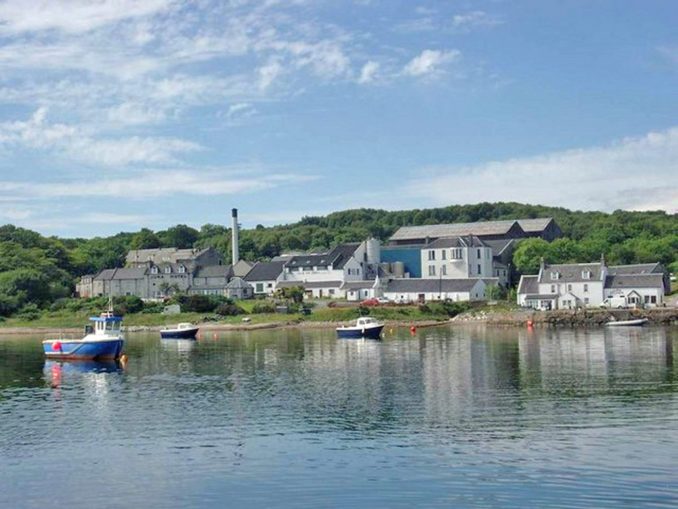
The most notable feature of Craighouse Bay was that of the Isle of Jura distillery. Here’s a photo taken in better weather than I had when it was just a looming presence at the head of the bay.
Listening to the evening weather forecast – ….Malin Force 8 ……. I thought the morrow might bring another day with no further progress.
JURA TO GIGHA
But in the morning the forecast had changed to …. SW Force 4-5 initially increasing 7-8 later……. and anxious to keep going after the delayed start on this leg I set off with yesterday’s sail plan of one reef in the main and the staysail.
As before, we made just over 5 knots parallel to Jura’s eastern shore whilst staying reasonably upright and I remained undecided about whether to head for shelter behind Gigha or carry on to Port Ellen on Islay.
Once past the SE tip of Jura we were exposed to stronger winds of 25-30 knots with rolling waves some 5-6 feet high penetrating even this far up the Sound.
Alchemi stood up well to these stronger winds without change of sail plan and responded with an increase to maximum hull speed of 6.5 knots.
At this stage I abandoned all thoughts of trying to go down Islay’s SE coast to Port Ellen and instead to lay off the wind a bit and make for shelter behind Gigha.
The Pilot Book describes the approach in this way – “The Sound has the reputation of being difficult to navigate but in moderate weather and reasonable visibility will present little difficulty”. At the risk of including more technical detail than a general reader might want I reproduce the text of my journal describing what happened next –
The first point to identify when coming from the north is a group of rocks called Gamnha Gigha. With the pilot’s warning in mind I had prepared a tabulation of the co-ordinates for three waypoints down the Sound, the first of which was between the rocks and a reef to the north of Gigha itself. There, I needed to make a sharp turn to a course of 100 degrees magnetic.
I thought this would be straightforward if only the boat’s installed GPS was working properly and transmitting its signal onto the primitive electronic chart – but by this stage of the voyage it had gone on the blink completely. I was therefore using a paper chart, my tabulation and a hand-held back-up GPS that ate batteries like no one’s business.
There were one or two anxious moments as we passed across some shallows into the deeper water of the Sound and I must have left the turn a little too late because we were clearly going to pass closer to the rocks than planned by the time I had sight of them for the first time.
Nevertheless we made a few more degrees to windward by tightening the sheets after making the turn and coming into sight of two buoys ahead that we had to pass between.
Then came a stronger squall with low cloud and a belt of rain that completely obscured the buoys, Gigha and the Kintyre peninsula. It would have also obscured Gamnha Gigha itself if I had not been so close. At this stage I thought “one can take sailing purity too far” and switched on the engine and radar.
The squall passed after 15 minutes or so and I was soon able to take down the sails and moor to a buoy in Ardminish Bay.
The evening forecast predicted …… south-west winds force 6-8, occasionally 9……., so I looked forward to another day tied to a buoy waiting for the gale to pass before tackling the North Channel between the Mull of Kintyre and Ireland.
Feeling at peace with this decision and having time on my hands I enjoyed an excellent roast lamb dinner with plenty of vegetables whilst listening to The Magic Flute and afterwards to Mahler’s seventh symphony.
The feeling of peace didn’t last very long and I awoke just before 01:00 with the wind howling in the rigging and the boat bucking about like a mechanical horse in a fun fair. I felt relieved at my decision to come to Gigha and forebore to think what conditions must have been like at Port Ellen, fully exposed to wind, waves and swell from the south.
The morning’s forecast was for ….. gale force 8 imminent, increasing to 9 soon ….. with the promise of some moderation and veering to west or west-north-west on Tuesday.
The worst of the wind today came just before dawn and it moderated to a steady force 6 during the morning. I wasn’t tempted to discover how strong it was across the open sea and used the time to look at the best way to cross the North Channel. None of my pilot books were very helpful but they all warned of the composite problems of strong tides, overfalls, a propensity for rough seas, busy shipping lanes and so forth.
I decided I should aim to reach Red Bay on the East coast of Ireland about 12 miles south of the north eastern tip of the island.
Currents in the North Channel are very strong as the Irish Sea fills and empties with the moon though not as strong as those in the Pentland Firth because the Channel is much wider. The configuration of the channel and land masses also result in the currents being in either a south easterly or north westerly direction and I clearly had to catch the former to avoid being carried away from my destination.
It turned out that to optimise my use of the tides I needed to be off the southern tip of Kintyre at High Water Dover and that meant it would be dark either when I left Gigha or arrived at Red Bay. I chose to plan my passage to arrive in the dark because Red bay has fewer hazards than the southern end of the Sound of Gigha.
GIGHA TO RED BAY
The forecast for Malin on Tuesday morning was for gales but no higher than force 7 in inshore waters. Needing to be at Bangor by Saturday and reluctant to further postpone departure I rigged the boat with two reefs in the main and the storm jib whilst still attached to the buoy.
Navigation and boat handling were quite demanding as we set off with the winds becoming stronger and the waves higher as we made our way past rocky hazards on either side. There were no visibility problems today but it was with a feeling of relief that I began eventually to pull away from the small island of Cara in uncomfortably short and steep waves in a wind of around 30 knots.
A spell of chart table work had me feeling distinctly queasy but a retreat to the cockpit and a period gazing at the horizon put that right as the wind rose to 36 knots and Alchemi raced along at 6 knots with rather more heeling than I liked.
Suddenly, there was a windshift of 90 degrees and reduction in strength to 15 knots. Amazed that conditions could change so quickly I waited an hour before doing anything more than rolling out the staysail. After that time the sea had quietened down considerably and the wind seemed steady so I changed the storm jib for the Yankee and took out a reef in the main.
Passing the Mull of Kintyre only 30 minutes behind plan I was able to let out the Yankee some more and enjoy one of those rare sails at 7 knots through the water and 11 knots over the ground as the tide built up to maximum speed.
That was so exhilarating I allowed it to continue longer than I should have done and ended up having to motor-sail into Red bay in the dark and, with the aid of the radar, found anchorage not far from two local working boats moored to buoys nearby.
RED BAY TO BANGOR
Wednesday morning was a complete contrast. As I left the anchorage there was a light 6 knot breeze from the north west that tempted me into setting the full main and poling out the yankee.
No sooner had I set up this arrangement than the wind dropped away altogether and I had to take it all down again as we rocked gently in a flat calm.
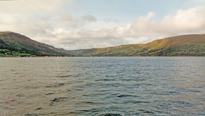
The weather was warm and the sky clear. I could see the entire North Channel to the Mull of Kintyre, up the Clyde estuary and across it to Ailsa Craig and the Ayrshire and Galloway coasts.
I couldn’t help reflecting that had I postponed my departure from Gigha by 24 hours I could have serenely motored the whole passage that gave me so much excitement the day before. That thought was soon replaced by the reflection that in solo sailing under yesterday’s conditions I had passed another milestone in my seagoing experience.
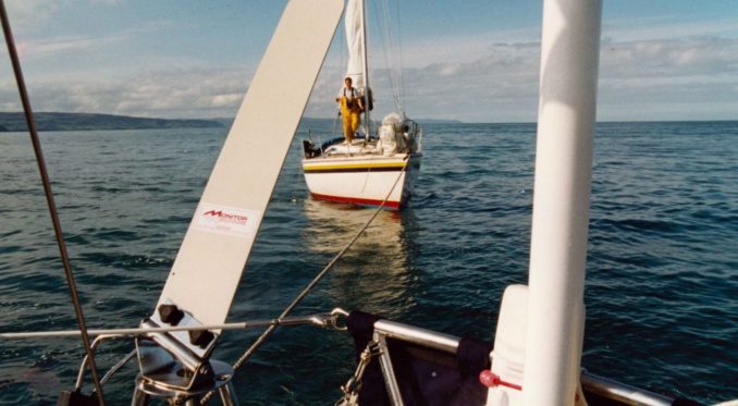
Today of course I had to motor and did so until just off Larne when I saw another yacht sailing ahead of me. Thinking that if there was enough breeze for him there should be for me I stopped the engine and set sail again. But the wind was so slight and the current building that I soon found myself going back towards Red Bay.
Meanwhile the other yacht had worked its way towards me close enough for the skipper to wave to me with a “come hither” action. By this time I was close enough to see the yacht was named “Gunsmoke”and that made me hesitate to do what he wanted. I found the name rather ominous in an area redolant of so much injury and death in the recent “Troubled” years. Still, the skipper and his girl friend looked friendly enough and I relaxed when it became clear he had in mind a cry for help rather than an act of Piracy.
The skipper explained they had been hired by the owner to make a delivery passage from Donegal to Strangford Loch and they couldn’t start the engine. Like Alchemi, they were being carried by the tide in the wrong direction.
Thinking it ironic I had stopped my engine because he couldn’t start his we took down all sail and I towed them in to Bangor marina some 12 miles farther south.
This experience and working out with the marina staff how and when to throw off the tow rope whilst leaving “Gunsmoke” with sufficient way on her to reach a pontoon enlivened what would otherwise have been a pleasant but rather dull day.
BANGOR
Bangor is now a seaside town on the southern shore of Belfast Lough about 10 miles NE of the Northern Ireland capital.
The town grew up around a Monastery established in the middle of the 6th Century AD famous for its learning until it was ravaged by Viking raids in the 8th and 9th centuries. Fortunately some of the learned texts had been taken to the European continent by monks fleeing from the raiders and are now preserved as precious manuscripts.
It wasn’t until 300 years later that christianity was re-established with the constuction of the first stone church but the town seems to have remained very small and quiet until another 300 years had passed when the end of the Tudor period in England brought major changes.
It is well known Elizabeth I was childless but perhaps less well-known to the general reader that as a consequence there was much political jostling for position as successor during her reign. There were many claimants each of whom sought supporters who would need to be rewarded if the principal succeeded to the throne.
It is also well known James VI of Scotland finally succeeded Elizabeth to become James I of England as well. I first learned the reason why the Stuart Dynasty inherited the Crown in an exhibition in Bangor Town Hall! The key to his success was that his mother was Mary Stuart, Queen of Scots, and her Grandmother was Margaret Tudor, sister of Henry VIII who had married James Stuart, then King James IV of Scotland.
One of the ways James VI of Scotland and I of England rewarded his supporters was by granting them land-rights in Northern Ireland. Many of these new land-owners were Protestant Scots.
James Hamilton was one of James Stuart’s most important agents during this period and based himself in Bangor though he also had extensive lands in other parts of the North Down region. Elements of his reward were that Bangor became a Borough entitled to send two MPs to the Parliament in Dublin and a Port in 1620 resulting in Hamilton building a Custom House in 1637 from which I have little doubt he and his Scots settlers derived benefit in some way or the other.
Dispossessed landlords and inhabitants before the arrival of the Scots were naturally put out by being disadvantaged in this way and I found this exhibition more illuminating than simplistic suggestions Irish antagonisms are rooted in a difference between the Catholic and Protestant faiths.
Bangor developed a new lease of life in the Victorian and Edwardian eras when Industrial development and construction of a railway from Belfast resulted in it becoming a fashionable seaside resort for the rich and an easily accessible place for a day out for the poor.
In 1997 UK Government grants over the previous 15-20 years resulted in a new high-quality marina and other investment in shopping centres, restaurants, hotels and so on. The town had an air of prosperity that made Oban seem a little tatty and Stornaway positively dowdy.
I’ve not returned since and can only imagine the centuries old tensions still remain, currently inflamed by the failure of the UK and EU to agree a way of protecting their respective Single Markets. It seems likely to me any solution the politicians agree will be a fudge that may or may not survive their terms of office.
To be continued …………….
© Ancient Mariner 2022