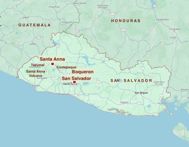
Leaving the Pan-American highway and heading west beyond the urban sprawl of second city Santa Ana, we follow the route of the El Salvador Railway Company’s Ahuachapan branch line which we discovered last time. Nothing of the narrow gauge route survives except a dirt track away from the main road with locals’ improvised houses and small holdings dotted along either side.
We’re travelling to the town of Chalchuapa, which itself sprawls to over 70,000 inhabitants with the remains of historic Tazumal these days surrounded by suburbs.
© Always Worth Saying 2024, Going Postal
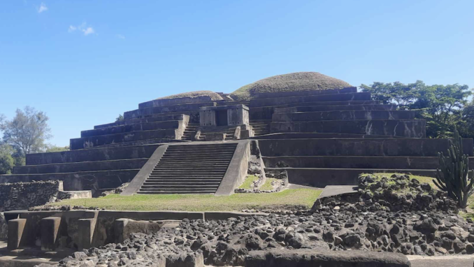
Tazumal is one of the most significant and well-preserved Mayan archaeological ruins in El Salvador. This ancient site dates back to the pre-Columbian era (ie before Christopher Columbus) and offers valuable insights into the cultural and historical heritage of the region.
The Tazumal complex is believed to have been inhabited as early as the 4th century BC and was a thriving urban area during the classical period. The ruins features a series of impressive structures, including pyramids, plazas and residential areas, showcasing the architectural and engineering prowess of the Mayan people.
One of the most prominent buildings at Tazumal is the pyramid, which served as a ceremonial and administrative centre for the Mayan inhabitants. The intricate carvings and hieroglyphic inscriptions found on the stelae and altars in the complex provide valuable information about the religious and historical practices of the ancients.
Excavations began in 1940 under the interesting Stanley Harding Bloggs (1914-1991). Pictured in 1952 much of the site was still a heap of earth and vegetation.
Bloggs was born in Warsaw, Indiana, the son of farmer Stanley Snr and his wife Mary. A graduate of Chicago’s Northwestern University, Bloggs took a Master’s in Anthropology from the University of Arizona and completed his studies with three years at Massacuesteses prestigious Harvard.
By now it is 1940 and upon the recommendation of a Mr A V Kidder, Bloggs Jnr ventured to El Salvador. His first excavations at Tazumal followed in 1942 during which he married a Salvadoran girl, Ines Sagera Rosales, and began a lifelong love of the country which he made, with one or two interruptions for civil war, his home. Going native, when his wife died, Stan married his sister-in-law, Berta Sagrera Rosales
In 1950-51 Bloggs constructed a new museum, went on to author a monograph of Tamuzal and to outline an archaeological sequence for much of the country. Rather than describe a general synthesis of the local archaeology, he preferred to write about artefacts or artefact types of significance to him.
His most important studies were of wheeled figurines, musical instruments and Middle Preclassic figures and their clothing. As such his work is free of the ‘white man bad’ nonsense which permeates woke academia these days. Subsequent decades of research have shown that rather than being destroyed by the Conquistadores, Tazumal was a Mayan settlement existing during the Mesoamerican classic and post-classic periods.
© Google Maps 2024, Google licence
By way of explanation, Mesoamerican refers to the historical and cultural area extending from the southern part of North America to the Pacific coast of Central America. The classic period is 150AD to 950AD with the post-classic defined as 940AD to 1521AD. The early 16th century being the time of first contact with Europeans.
Evidence shows Tazumal was a Mayan settlement from the earliest part of the classic until 1200AD when the pottery trail fizzles out. Therefore, when the Conquidtaores arrived there in 1524, they set eyes upon a Tazumal abandoned for more than three centuries. However, nearby at the original Chalchuapa, there remained a Mayan-descended population.
Observing the remains allows an opportunity to ponder the history of El Salvador.
A Brief History of El Salvador
Prior to the arrival of the Spanish, the region of present-day El Salvador was inhabited by indigenous peoples with their own societies, agricultural practices, trade networks and cultural traditions. Notably, the Maya civilization influenced the western part of El Salvador and left behind archaeological sites including Tazumal.
In 1524, the Spanish conquistador Pedro de Alvarado led the conquest of El Salvador, marking the beginning of Spanish colonial rule. The indigenous population faced upheaval and disruption as a result of the conquest. The Spanish established colonial settlements and their language, religion and governance dominated the native communities.
El Salvador remained under Spanish colonial rule for almost three centuries, during which time it was part of the Captaincy General of Guatemala. The region’s economy revolved around agriculture, with the exploitation of indigo and later coffee becoming central to its colonial economic structure.
El Salvador, along with other Central American territories, declared independence from Spain in 1821. The independent nation joined the First Mexican Empire before becoming part of the United Provinces of Central America. However, internal conflicts and regional tensions resulted in the dissolution of the federation and El Salvador emerged as an independent republic in 1841.
The 19th and 20th centuries were marked by political instability, internal conflicts and power struggles. The country experienced several periods of authoritarian rule, including the lengthy presidency of General Maximiliano Hernández Martínez in the mid-20th century.
Throughout the 20th century, El Salvador grappled with social inequality, land reform issues and tensions between the ruling elite and the marginalized rural population. These tensions culminated in the Salvadoran Civil War which lasted from 1980 to 1992 and resulted in significant loss of life.
Santa Ana Volcano
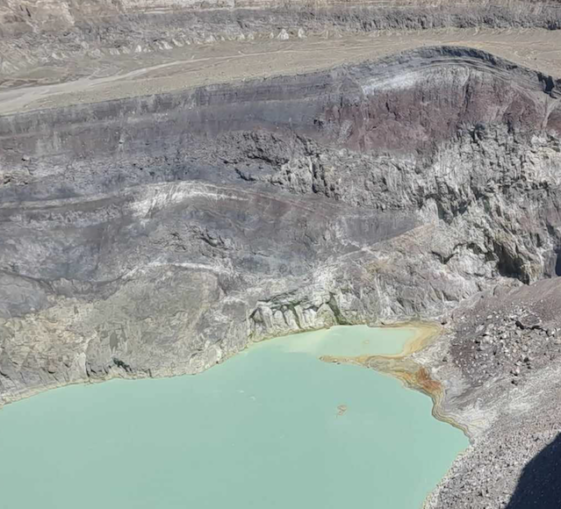
Although the railway line avoids the mountains and heads east and south to join the Pacific coast, the road takes a more direct route and allows a visit to the Santa Ana Volcano. Also called Ilamatepec, it is the highest volcano in El Salvador and one of the most active in the country. Standing at 7,812 feet above sea level, the Santa Ana is part of a chain of volcanic mountains known as the Central American Volcanic Arc. This in turn is part of the Pacific Ring of Fire.
© Always Worth Saying 2024, Going Postal
© Always Worth Saying 2024, Going Postal
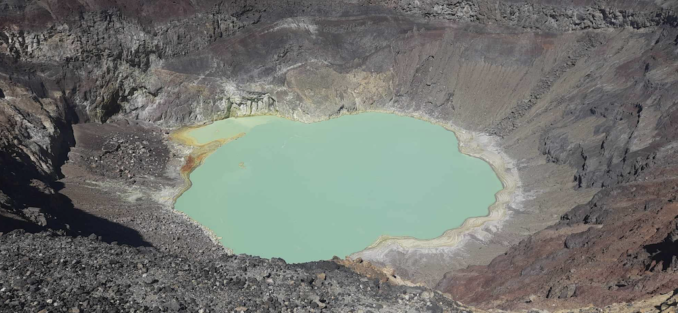
The volcano is characterized by a wide crater, about one mile in diameter at its widest which contains a stunning turquoise-green crater lake. Despite its potential hazards, the Santa Ana Volcano and its surrounding areas are popular tourist destinations. Visitors can hike to the summit to witness panoramic views of the landscapes and the beautiful crater lake. The hiking trail to the top offers a mix of lush vegetation and rocky terrain, providing an exciting and challenging adventure for outdoor enthusiasts.
A stratovolcano with a history of frequent eruptions, the most recent significant eruption occurred in October 2005 and resulted in the temporary evacuation of nearby communities. The first since 1904, ash, lava, rocks as big as cars and a boiling flood of muddy water were produced amongst copious quantities of sulphur dioxide.
Detectable from outer space, NASA’s Aura satellite’s Ozone Monitoring Instrument reported 20,000 tons of sulphur dioxide entered the atmosphere in one day with half of the mass floating in a cloud westward over the Pacific Ocean.
The area surrounding the Santa Ana Volcano is part of the Apaneca-Ilamatepec Biosphere Reserve, recognized for its ecological importance and biodiversity. The volcano and its surroundings are home to diverse flora and fauna and, despite its activity, continues to be a prominent feature of the country’s landscape and a source of interest for visitors and researchers alike.
Izalco, The Lighthouse of the Pacific
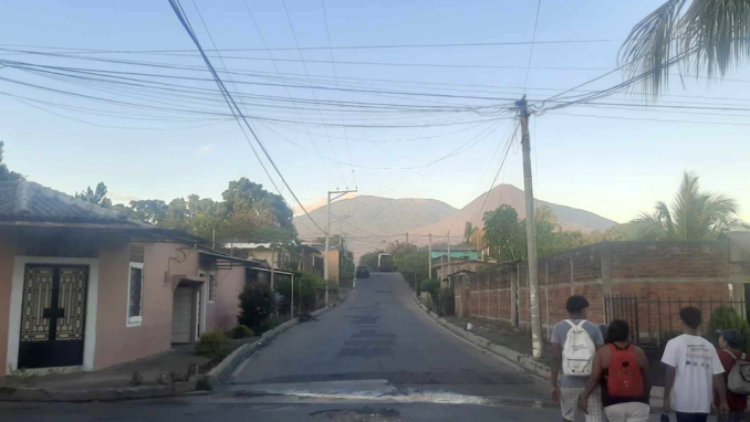
From nearby small town Central America we can pause for a moment and take in a Ring of Fire horizon including Izalco, the conical mountain to the right of the flat-topped Santa Ana Volcano.
© Always Worth Saying 2024, Going Postal
Followers of Ripley’s ‘Believe It Or Not!’, a syndicated newspaper cartoon from a mere half-century ago, are already aware Izalco is,
‘The strangest volcano in the world, sitting at 7,828ft in height and is so continuously active that for 200 years mariners have used it as a lighthouse.’
Izalco, known as the “Lighthouse of the Pacific,” is another stratovolcano, this time located near the city of Sonsonate. It gained international attention for its continuous and spectacular nighttime lava displays, which led to its nickname. The volcano emerged in 1770, and its frequent eruptions earned it the reputation of being an ‘Eternal Lighthouse.’
In response to Mr Ripley, one’s obliged to reply ‘not’. The actual height of Izalco is 6,398 ft and it has sat dormant since 1958.
While Izalco’s volcanic activity has decreased in the late 20th century, it remains an important geological and cultural landmark in El Salvador. The volcano and its surroundings are part of the Cerro Verde National Park, where visitors can experience the natural beauty and geological history of the region.
Arriving too late for the party, an April 1959 London Illustrated News correspondent noted,
In 1770 not a sign of this towering and barren mountain existed. In its place was a cornfield. Suddenly the field burst into a volcano which rapidly climbed upwards, spreading such an overflow of flaming lava around it that it soon earned for itself the name ‘Lighthouse of the Pacific.’
Izalco is now one of the twelve or more major volcanoes in the small Central American country. Approaching twice the height of Snowdon, it grew for two hundred years, engulfing the surrounding countryside in dust, stones and flowing lava.
© Always Worth Saying 2024


