
As every schoolboy knows, off the southern coast of the province of Cadiz the 3rd August 1704 ended briskly as Sir George Rooke’s fleet bombarded the Spanish isthmus of Gibraltar. The following morning, 1,900 English and 400 Dutch Marines landed resulting in the Governor surrendering and Rooke, with the agreement of all present, hoisting the British flag over the western gateway to the Mediterranean Sea.
It must be noted, that’s not how the Dutch contingent, under the command of Prince George of Hesse-Darmstadt, recall the day nor do the difficult-to-please Spaniards. Never mind. The Union Flag still flies over the territory. No matter what the lawyers may tell you, in this case, more than three centuries of possession trumps any 18th-century international or local law.
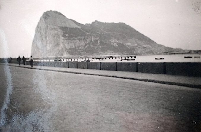
Two hundred and forty-eight years after Rooke, a heroic Ford 8 hurried that way from Torremolinos carrying my father and grandparents. Pausing to picture the coastline, flatness and a distant sea suggests the caption ‘Straw shacks near Gib’ to be correct. The coast road is hilly and doesn’t become level until approaching Santa Margarita only three and a half miles from the Crown colony.

© Always Worth Saying 2022, Going Postal
I suspect turning slightly to the right would have revealed Gibraltar itself, perched in the sea like a giant capsizing ship hewn from bleached rock. As for the straw huts, they are visible at the bottom right of the photograph, somewhat in the gloom. In the modern-day, on Street View, there is no sign of any straw structures. Some single-storey whitewashed stone buildings, such as the one in the middle distance in the old photo, have survived. In ones and twos, they are dotted among more modern developments and better-cultivated farmland.
In today’s aerial photographs, this part of the coastal road looks so straight that it suggests a recent embankment enclosing the land from encroachment by the sea. Fine beaches now predominate rather than scruffy gauze bushes leading to marshland.
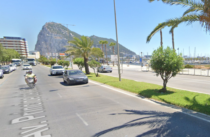
A classic view of the Rock, that can still be observed today from the same angle, is captured in the next picture. The section of the bay to the right is the Puerto Deportivo Alcaidesa Marina, part of the township of La Línea de la Concepción which sits on the Spanish side of the border.
© Always Worth Saying 2022, Going Postal
© Google Street View 2022, Google
The day after Rooke arrived the locals packed up and left, wary the place was about to become a battleground constantly under siege. They founded their own town of San Roque which lies about four miles inland as the crow flies. It retains a certain charm. Not something ever said of La Línea which is a dump now as it was in the 1950s. Perhaps surprisingly, the population isn’t much higher today but has sprawled and been housed in concrete blocks. Seven decades ago the natives lived in shanty towns of tin sheds and straw huts which, fortuitously for the English travelling lower-middle classes, didn’t spoil photos of the view.
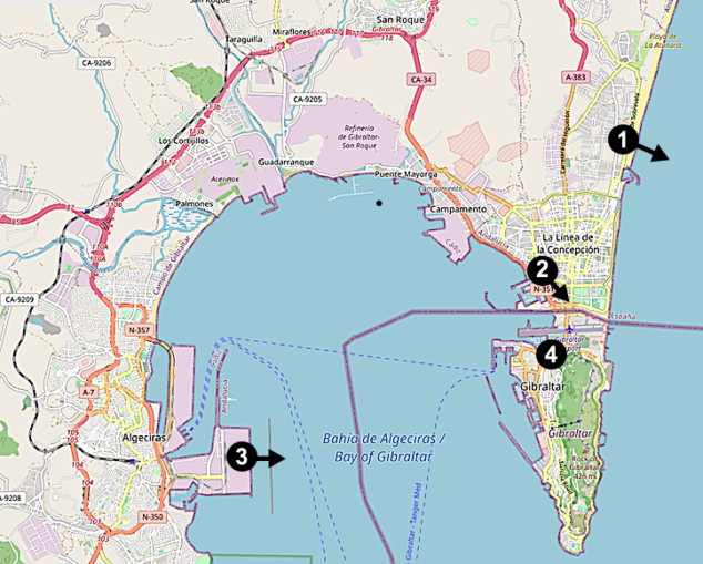
As for me, four decades ago and three decades after my father and grandparents, I preferred the train and would travel overnight from Madrid. Looking through old timetables and tickets, I can’t quite make sense of it. Added to which I’ve reached an age where I struggle to discern between what I remember, what I imagine and what I’ve seen someone else do on the telly. Unlike Rooke and my recent ancestors, I approached from the north and the west as you can see from the railway line in Map 1.
OSM Gibraltar,
OpenStreetMap.org and its contributors – Licence CC BY-SA 2.0
My little UIC timetable, short of detail, has me leaving Madrid at 2020 (I recall Atocha, it insists me to Chamartin – I suspect the train called at both) and arriving at Algeciras at 0830 the next morning. I can’t get this to fit with the fuller old timetables. As with the stories in the Gospels, we shall assume these inconstancies to be proof of truth.
What I can say with certainty is a distance of 461 miles was timetabled for 12 hours and 10 minutes which calculates to a stately 37 miles per hour. I can remember waking while passing the city walls of Cordoba. After which there followed a round-robin tour of the provinces of Andalusia and Cadiz as the train made the most of mountain passes and lesser gorges conquerable by viaduct.
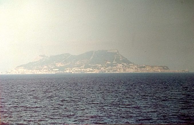
Destination Algeciras offers nothing. Its only claim to fame being it’s worse than La Línea. Even 40 years ago it had the smell of North Africa about it. Rather than avenues, narrow concrete trenches, stifling the most enthusiastic of visitors, run down to the harbour from the railway station. Nearby were docks and a ferry port. The rest of the bay was lined with oil refineries. One redeeming feature was the view.
© Always Worth Saying 2022, Going Postal
While spotting names in the old ferry timetables, one can’t help but notice the duplicitous Spanish have territory in North Africa (at Ceuta and Melilla) while complaining we have a bit of Spain. Hipócritas! Back on the other side of the bay and back in the 1950s, the Ford 8 will have driven across the airport. Then and now, the runway runs west to east with the road blocked off on each side when air movements necessitate.
Constructed in anticipation of the Second War and opened in 1939, our intrepid travellers will have crossed the tarmac into Gibraltar proper as do visitors to this day. In his book, Royal Marine Commandos, John Parker gives us an idea of the importance of the colony in World War Two.
but it was only the beginning [following the sinking of Vichy France’s fleet] of tremendous activity in the Mediterranean, which became a lifeline in so many ways to those fighting to maintain Britain’s control of North Africa and the Suez Canal. Never in history was the prize of Gibraltar, won by the Marines so long ago, so utterly crucial in keeping the thoroughfare open. Without it, Malta, Alexandria, and possibly the Suez Canal would have been lost.
Prior to preparations for the war, the land taken by the airfield had included a race course, Victoria Gardens, an officer’s cricket pitch and a Jew’s cemetery (which survives). To the south of the airfield lay boggy land. A causeway was constructed around it to connect to the west side of the isthmus. The newly enclosed land was known as the Inundation and was subsequently drained, reclaimed and built upon.
I’m indebted to Cpl Tim Hammond, MOD Command Photographer, and the team at the Gibraltar Garrison Library who provide such information through their excellent mapping project. For the use of all, the team have compiled, photographed and digitised 53 Ordnance Survey maps from the late 19th to mid-20th centuries and made them available online here.
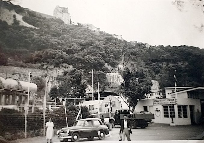
Hence we can trace the route followed by my father and grandparents and add some detail to what they saw. The next photograph will be of particular interest to Puffins (and I know there are one or two) who have served in the Special Forces. The Causeway met Devil’s Tower Road (which becomes the road lapping the eastern side of Gib) at a roundabout named the Sundial. Yards south of the Sundial was a garage presented in Picture 4. We can be certain of this location as a distinctive Moorish castle sits atop an escarpment to the rear.
© Always Worth Saying 2022, Going Postal
As early as 1908 the area is mapped as ‘workshops’ next to an isolation hospital. As well as being fascinating in itself, note the Nissan huts and the above-ground (gravity fed rather than pumped) fuel storage, the image has a second interesting story to tell. As you can see, it is a Shell garage. Looking at a 1941 map from the Garrison Library project, we see a series of buildings and sheds tucked below the rock and extending out towards the Causeway. To the right, the isolation hospital remains. Ahead, the gap between the Causeway and the Rock is part-reclaimed from the sea, however, the map notes the limit of reclamation as per 1932 with the 1942 update being, as ever, based upon an earlier map.
In the 1952 photograph, the slab-sided buildings to the right announce this to be a Shell service station. During and after wartime, we must think of this not as a service station but as a bigger facility. Subsequently, the Causeway was re-named Winston Churchill Avenue with the Shell garage reduced to a filling station rather than a fuel facility. By this time, it was located next to the road at the westernmost point of the old complex with, in the late 1950s and early 1960s, the rest of the land being covered by the Laguna Estate.
Special Forces chaps dozing at the back, pay attention now. Thank you.
It was here, on 6th March 1988, that two members, Daniel McCann and Mairéad Farrell, of a three-person Provisional IRA Active Service Unit were shot and killed by the SAS. They were making their way from the territory having parked a car they planned to replace with another car carrying a bomb. The third member of the ASU, Sean Savage, was shot and killed 300 ft south of the garage having split from the others and changed direction presumably as they suspected they were being followed.
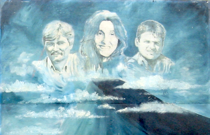
Belfast mural, Mairead Farrell,
Zubro – Licence CC BY-SA 3.0
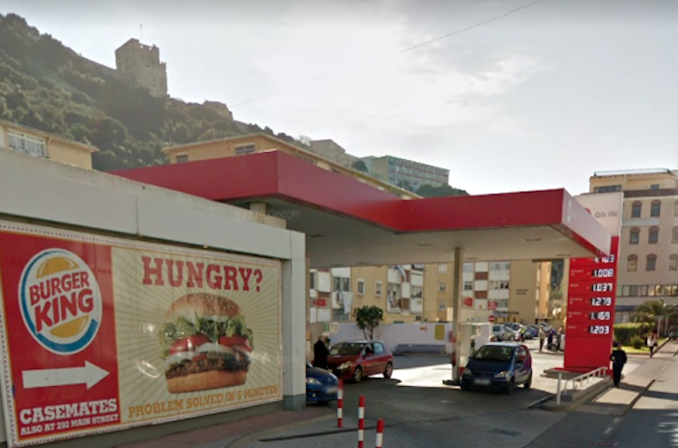
The filling station is still there, now branded GO (for Gibraltar Oil). A recent Street View photo taken from Winston Churchill Avenue, shows the Moorish Castle in the background as per the 1950s photo.
I knew an excellent chap in the Royal Navy. Stationed over there, his wife was stuck over here with two toddlers. She would visit for a holiday. Something cropped up at the Grey Funnel Line and the poor girl was trapped in a hotel room staring at the walls on her own while the little ones screamed. Nelson’s finest promised he’d pull a few strings and did manage to wangle an afternoon off. Catalan bay? Europa Point? No, he took them to the filling station so they could all have their photographs taken next to the bullet holes in the petrol pumps. In full uniform and medals. True story. Tells you something about the Senior Service.
© Google Street View 2022, Google
All well and good, but why did my father and his parents have to visit? Why did they have to drive all the way from Carlisle to Gib? The answer lies left of centre at the bottom of Picture 4. Eagle-eyed Puffins and former and current members of the Special Forces will already have twigged. The rest of you will find out next time on Nostalgia Album!
© Always Worth Saying 2022

