A METEOROLOGICAL DIGRESSION
Life on a small yacht is lived much closer to nature than most people in developed countries usually experience. That is particularly true about weather in its many forms and I’d like to start this article with a digression about electrical storms.
Even now, there is still no completely “settled science” about these because many different factors come into play. They have been observed on Jupiter, Saturn and Neptune as well as on Earth and possibly on Venus.
They can occur anywhere on earth but are said to be most common in the mid-latitudes between the tropics and polar circles due to collisions between cold and warm air flows in those regions. I can personally testify they are also common near the equator as there was one nearly every afternoon when I sailed up and down the North Coast of Borneo from Singapore in 2006.
Perhaps the most visually dramatic storm I ever witnessed was earlier in my life when standing on the roof of Meikles Hotel in Salisbury just after Zimbabwe became independent. This was before the city’s name was changed to Harare two years later. There was no rain but simultaneous vivid lightning flashes for miles around that lit up the landscape as though it was daytime.
The physics of electrical storms is complex but in simple terms they are caused by falling raindrops and ice particles meeting warm moist air rising from below. The collision between the two results in electrons being knocked off atoms that then have a positive electrical charge. The electrons are carried towards the bottom of the cloud and the now positively charged particles rise to the top. The entire cloud becomes an electrical capacitor with negative charge on the lower surface and positive on the top. The negatively charged lower surface of the cloud repels electrons in atoms on the earth’s surface that tends to become positively charged.
A volt is a unit of potential energy in electrical systems determining, together with electrical resistance, how much current flows between two objects having different voltages. Domestic voltage in the UK is usually about 240 and in the USA about 110. It is believed voltages between 1,000,000 and 1,000,000,000 can develop between the underside of a thundercloud and the surface of the earth. Passage through air rather than a wire is possible for a current to flow at that sort of difference and the energy just jumps across the gap with a visible plasma called lightning being formed by its movement and sound energy emitted as a clap of thunder.
An observer on earth will see the lightning flash more or less instantaneously but the speed of sound in the atmosphere at sea level is about 4.7 miles per second (varying with temperature, humidity etc) so a reasonable estimate of how far away the lightning struck can be made by counting the seconds. That is useful when sailing because thunderstorms are often accompanied by heavy rain preceded by a wind front in their vicinity with that system still travelling forward long after the electrical discharge has finished. Such systems typically travel at about 15 mph.
As an example then, say one is in a yacht at sea, comfortably sailing along at 4 or 5 knots with the self-steering doing its job and the sailor lying in the cockpit, sunbathing and reading a book. He looks up and sees a large thundercloud on the horizon from which a bolt of lightening suddenly shoots down. The sailor leaps to his feet, starts counting and throws the book into the cabin. If he’s lucky he doesn’t hear the thunder for 2 seconds and makes the following calculation – that must be about 10 miles away with the edge of the wind front being about 8-9 miles off – if its travelling in this direction at 15 mph it will hit me in about half an hour – that should give me time to put a reef in the main, furl the jib, close the hatches and get my waterproofs on.
Of course, that’s a fun scenario I’ve imagined for this article and if there’s thunder about a prudent sailor would have been on the lookout for a sudden weather change and not reading a book whilst sunbathing – but I’m sure readers will get the idea.
CROSSING THE NORTH SEA
Here is the map I produced at the time, providing an overview of the planned passage from Wolverstone to Kiel. I long ago lost the original file so I’ve obtained this copy by scanning the print in my Journal and some of the text shows through from the reverse side. I hope readers will not be too distracted by that and will accept it makes the map’s provenenace more authentic! Two companions had agreed to join me for the first leg of my Voyage and we left Wolverstone Marina on 17 May 1997.

There was a fierce thunderstorm on the first night and I can tell from my journal written soon after the voyage that I didn’t have the benefit of my own foregoing advice. Perhaps I should explain that I wrote a journal on my laptop as soon after the events as I could and sent it by email to my son. He was, and still is, a bit of a computer whizz and produced a large scale map on which he marked Alchemi’s position, printed out a copy of the latest episode, and used to take it with him on visits to my aged mother who was still living on her own at the time.
In the journal, I wrote about this night –
“…..there were vivid lightning flashes but the storm passed after a period of intense activity reefing in a wind of 20-25 knots and we were soon back to fewer than 10 knots over a calm sea shaking out the reefs once again”.
Clearly we were caught less well-prepared than my imaginary sailor. I’m not sure just how much sail we were flying before being hit by the wind front but imagine it would have been the full Main and Yankee if the breeze had been as light as 10 knots to begin with.
With that amount of sail and that windspeed Alchemi would have been moving over a calm sea at about 3.5-4.0 knots but if hit suddenly by 20-25 knots would have accelerated to more than 6.5 very quickly and also been heeling and probably pointing-up (changing direction towards the wind) because the increase in sideways pressure on the mainsail would not have been offset by enough sideways pressure on the Yankee to keep her “balanced”. There would also have been larger and steeper waves developing and it would have been dark because this was all happening at night.
That description helps an understanding of why I felt the need for two crew on board at that stage of my sailing life so we always had two people on watch at the same time and one resting. For similar reasons I was always very conservative about how much sail to fly when single-handing later on.
The next significant development was even more dramatic and I can do no better than quote from my journal again –
“Our next problem arose just south of Texel at one of the busiest junctions of sea-lanes in the Southern North Sea. The wind had died completely and we were motoring at six knots to cross the lanes before dark when there was a thump followed by severe prop shaft vibration.
After some time spent in the gathering dusk looking for any obvious cause we had to raise sail and were dependent on breezes of 2-3 knots to move at all – and it became dark and foggy with the sound of large ship’s engines reverberating through the night – scary despite using the radar to get advance warning of the course they were on. However, we survived and in the morning were able to sail away to safety in a light breeze of 6-10 knots.
When the sky brightened, by leaning over the rail we could see trailing lines from the propellor itself – so, it was on with the dry suit and goggles and over the side clasping the carving knife between the teeth again to cut away a mass of discarded fishing net. More anxiety caused by thinking about the possibilities than by actually getting on with it.”

This was the second occasion the propellor was stopped and this time at high rpm but again the yacht design and construction coped without damage or consequential problems once the cause of the stoppage had been removed. The third occasion wasn’t until many years later but it survived that too.
PASSING THE FRIESIAN ISLANDS
The northern coast of Holland is extremely low -lying and there’s a string of equally low islands just offshore stretching all the way past Germany’s north-west coast to south west Denmark. The area between the mainland and the islands is called the Wadden Sea but it’s a sea only at high tide. At low tide it’s mostly mud-flats containing a tracery of shallow and narrow water channels. It is famous as the locale of a novel featuring yachtsmen that was also a celebrated literary accomplishment that has never been out of print since it was first published.
Erskine Childers started writing “The Riddle of the Sands” in 1901 but didn’t finish it until early 1903 in time for it to be published in May that year.
Childers was born in England of Irish parents in 1870. In his twenties he became an enthusiastic owner of small sailing boats and made several cruises to and in the Wadden Sea enabling him to write authoritatively about the area in his remarkable novel. In the story, fictionalised versions of Childers and friends, cruise the narrow, shallow and muddy waterways of the Wadden Sea in a small yacht and discover the answer to a riddle posed by strange events. The story is made more credible than it might otherwise have been by the detailed and factually correct use of nautical terms and the descriptions of real places. (Spoiler warning – Germany was using the area to assemble and train a large number of troops who would invade East Anglia on barges specially designed for the mud-flat conditions in both countries).
Rudyard Kipling had published Kim two years earlier telling the tale of an orphaned boy in India in the time of the Raj, who gets caught up in the British Secret Service’s efforts to thwart Russian Intelligence’s attempts to displace Britain from the region and secure a “Warm Water” port for their own country.
Together, the two authors created a new genre in English literature – The Spy Novel – and were followed by John Buchan with “The Thirty Nine Steps”, by Ian Fleming with his Bond stories, John Le Carre with his about George Smiley, and many, many others.
“The Riddle of the Sands” became both popular and influential with many believing the establishment a few years later of British East Coast Naval Bases, such as Rosyth in Scotland, were decided upon because of Childers foresight, eleven years before WW I started, that the North Sea would become a critically important arena in the event of conflict – which indeed it did.
ANOTHER DIGRESSION
I can’t resist the temptation to relate more about Childers life and its political aspects that echo to this day.
In Childers late teens, Irish MP’s held the balance of power at Westminster between Gladstone’s Liberals and Lord Salisbury’s Conservatives. At the time, Irish Catholics and Protestants both supported Charles Parnell as leader of their MPs and there was a real possibility all would agree to the formation of an independent and united Ireland within the British Empire. That did not happen because Parnell lost the unanimous support of Irish MPs as a result of revelations about his long adulterous relationship with Katharine O’Shea, the love of his life.
Thereafter the divergence widened until Catholic Republicans declared Irish Independence in 1919 and that led to war with the British that continued for two years. Childers, who had been active in Irish politics for some time, was Secretary General of a team that negotiated the terms of an Independence Treaty with the British. But, the Treaty was based upon the notion of Southern Ireland becoming a Dominion with the same constitutional status as Canada and Australia, acknowleding the British Monarch as Head of State, and thus requiring a similar Oath of Allegiance to be sworn to the Monarch by all Irish MPs (and others).
At the same time the six counties of Ulster promptly declared themseves to be Northern Ireland and a part of the United kingdom. In the South, the Irish Free State agreed to the Treaty but Civil War with those who opposed it broke out six months later . Childers who had argued against the idea of a continuing tie to the British Crown joined the anti-treaty party but in November 1922 was arrested when found to be carrying a pistol and later executed. The Civil War ended in May 1923 in defeat for the anti-treaty forces.
But that didn’t end the disagreements and nor did removal of the Oath of Allegiance from the Constitution in 1933 or the fact Eire became a Republic with its own President as Head of State in 1949.
Beneath the peaceful surface the fires of Republican ambition and violence still flickered until bursting out again in the “Troubles” that started in the late 1960’s and continued for about thirty years until the Good Friday Agreement again quietened them. But will even that respite survive now passions have again been aroused by the EU’s insistence on Northern Ireland remaining a part of their customs union and Joe Biden’s posturing to his domestic voters emphasising his Irish heritage? My grandchildren will learn the answer.
THE ELBE AND CUXHAVEN
The river Elbe rises in the Czech Republic and drains much of northern Europe on its 700 mile journey to the North Sea. Germany’s largest port of Hamburg is about 70 miles from its mouth and the smaller port and seaside resort of Cuxhaven is about 5 miles from the estuary.
All large craft using the river are obliged to report by VHF Radio to a Maritime Traffic Control authority in the same sort of way that planes are required to take instructions from Air Traffic Controllers. This type of radio traffic cannot simultaneously transmit and receive a two-way conversation and can seem rather stilted because of this with people at each end of the exchange having to identify themselves every time they transmit and speak in short, clear sentences. I think small craft in the Elbe may be exempt from the requirement but I remember calling the Authority anyway –
Elbe Traffic Control, Elbe Traffic Control this is Yacht Alchemi, Yacht Alchemi.
Yacht Alchemi. Good morning Captain, this is Elbe Traffic Control
Elbe Traffic Control – this is yacht Alchemi requesting permission to enter the river and go to the marina in Cuxhaven
Yacht Alchemi – Yes Captain, you may proceed. Please call again when you reach the harbour.
Elbe Traffic Control – Yacht Alchemi – Thank you. Will call on arrival.
I remember being impressed with the respectfully formal way the controller spoke and his totally calm delivery both during that conversation and when listening to him receiving and making calls to others. His manner was identical whether talking to a small yacht or a large commercial ship.
That radio conversation was early in the morning as a fresh wind blew up giving us a terrific sail to Cuxhaven tacking all the way between the edge of the shipping channel on one side and drying sands on the other. My journal records
“This was so exhilarating we sailed with great style right into the marina at Cuxhaven, through a narrow entrance with a 5-knot cross tide.”
Cuxhaven is a small seaside town with about 50,000 inhabitants but well provided with basic shops. We replenished milk, bread and fresh vegetables but only stayed one night.
THE KIEL CANAL
The 60 mile long canal connects the Baltic to the North Sea via the river Elbe. It is 100 feet wide and 35 deep and was built in the late 1800’s to permit the passage of large Commercial and Naval ships as German unification and industrialisation started to challenge the dominance of the seas exerted by the British Navy over the previous 200-250 years.
It replaced the longer, more tortuous, narrower and shallower Eider canal built about 100 years earlier under Danish sovereignty between Holtenau just north of Kiel and Tonning where it joined the North Sea.
The Kiel canal’s link with the river Elbe is actually at a lock in the town of Brunsbuttel just under 20 miles upriver from Cuxhaven. My journal again –
“A good breeze the following morning enabled us to tack up the Elbe to the Kiel Canal entrance locks at Brunsbuttel. Pilot books emphasise the need for a favourable tide when sailing on the Elbe and we appreciated this advice with the current being 3-5 knots in our favour; the passage would have taken all day had they been adverse”.

The canal is still used by large ships including Cruise Liners.


In common with similar regulations in other major canals around the world we were required to motor through this one and not allowed to travel overnight. We stayed at a pontoon in the Gieselau canal about half-way between Brunsbuttel and Kiel.
“The following morning was bright and sunny with much birdsong from the adjacent nature reserve”
Passage into the Eider Canal is possible here and then on to the river. The word Eider is apparently derived from the ancient Norse word for “Duck” so I guess the river and particularly its estuary got its name from the birds as a place where they were commonly found. What is now known is that they are fast-flying ducks widespread in temperate climates where they feed on salt water molluscs and have marvellously soft breast feathers from which light and warm bedding can be made.
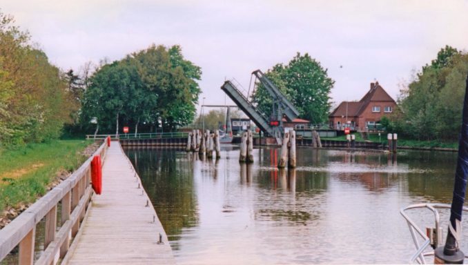
Completing the passage through the Kiel canal the following day was easily accomplished as was passage through the Locks at Kiel.

Despite all the yachts in this photo heading for the gates on the right of the picture Alchemi was directed to use the ones on the left when we went through. I guess traffic management varies their use from time-to-time.
“As soon as the Lock Gates opened at the northern end of the canal we were struck by the beauty of the Kieler Fjord. Its tree-lined banks and sparkling waters are such a contrast to the muddy browns and greys of the Elbe and the North Sea”.
We stayed for two nights at the British Army’s adventure and training establishment – the British Kiel Yacht Club – and enjoyed a day off just relaxing in the sunshine.

This club, set up as an establishment operated by the BAOR (British Army of the Rhine) was closed in September 2016 some 12 years after that army was disbanded 76 years after its formation (for the second time – there was also one with the same name formed after WW I – both were armies of occupation). So the British Kiel Yacht Club had a good run for the taxpayer’s money and mooring fees paid by passing yachtsmen. I haven’t noticed a reduction in taxes as a result of its closure but expect other uses have been found for the funds – though I’m sceptical about the likelihood they provide better value for money.
To be continued …………….
© Ancient Mariner 2021
The Goodnight Vienna Audio file